
Topografische Karte Manitoulin District
Interaktive Karte
Klicken Sie auf die Karte, um die Höhe anzuzeigen.
Über diese Karte
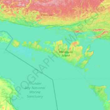
Name: Topografische Karte Manitoulin District, Höhe, Relief.
Ort: Manitoulin District, Ontario, Kanada (45.36070 -83.50673 46.13040 -81.07103)
Durchschnittliche Höhe: 211 m
Minimale Höhe: 171 m
Maximale Höhe: 529 m
Andere topografische Karten
Klicken Sie auf eine Karte, um ihre Topografie, ihre Höhe und ihr Relief anzuzeigen.
Latchford
Kanada > Ontario > Timiskaming District
Latchford, Timiskaming District, Northeastern Ontario, Ontario, P0J 1N0, Kanada
Durchschnittliche Höhe: 346 m
Bowmanville
Kanada > Ontario > Bowmanville
Bowmanville, Durham Region, Golden Horseshoe, Ontario, L1C 1N2, Kanada
Durchschnittliche Höhe: 112 m
Mississauga
Kanada > Ontario > Mississauga
Mississauga, Peel Region, Golden Horseshoe, Ontario, Kanada
Durchschnittliche Höhe: 152 m
Grand River
Grand River, Wellington County, Southwestern Ontario, Ontario, N0B 2V0, Kanada
Durchschnittliche Höhe: 300 m
Nipigon River
Nipigon River, Thunder Bay District, Northwestern Ontario, Ontario, P0T 2P0, Kanada
Durchschnittliche Höhe: 297 m
Young Island
Kanada > Ontario > The Archipelago
Young Island, The Archipelago, Parry Sound District, Ontario, Kanada
Durchschnittliche Höhe: 197 m
Ontariosee
Kanada > Ontario > Quinte West
Ontariosee, Quinte West, Central Ontario, Ontario, Kanada
Durchschnittliche Höhe: 215 m
Timiskaming District
Timiskaming District, Northeastern Ontario, Ontario, Kanada
Durchschnittliche Höhe: 331 m
Niagara River
Kanada > Ontario > Niagara Falls
Niagara River, Niagara Parkway, Niagara Falls, Niagara Region, Ontario, L2G 6Z9, Kanada
Durchschnittliche Höhe: 177 m
DeCelles Island
Kanada > Ontario > The North Shore
DeCelles Island, The North Shore, Algoma District, Ontario, Kanada
Durchschnittliche Höhe: 224 m
Winnipeg River
Kanada > Ontario > Unorganized Kenora District
Winnipeg River, Unorganized Kenora District, Kenora District, Ontario, Kanada
Durchschnittliche Höhe: 323 m
Flour Mill
Kanada > Ontario > Greater Sudbury
Flour Mill, Greater Sudbury, Ontario, P3C 5J7, Kanada
Durchschnittliche Höhe: 276 m
Cumberland
Kanada > Ontario > Ottawa > Cumberland
Cumberland, Ottawa, Eastern Ontario, Ontario, Kanada
Durchschnittliche Höhe: 75 m
Thunder Bay District
Thunder Bay District, Northwestern Ontario, Ontario, Kanada
Durchschnittliche Höhe: 321 m
Rivière la Martre
Kanada > Ontario > Unorganized Kenora District
Rivière la Martre, 325, Unorganized Kenora District, Kenora District, Ontario, Kanada
Durchschnittliche Höhe: 427 m
Nipigonsee
Kanada > Ontario > Unorganized Thunder Bay District
Nipigonsee, Unorganized Thunder Bay District, Thunder Bay District, Northwestern Ontario, Ontario, Kanada
Durchschnittliche Höhe: 307 m
Red Rock River
Kanada > Ontario > Unorganized North Algoma
Red Rock River, Unorganized North Algoma, Algoma District, Ontario, Kanada
Durchschnittliche Höhe: 395 m
Victoria Island
Victoria Island, (Old) Ottawa, Ottawa, Ontario, K1R 1C5, Kanada
Durchschnittliche Höhe: 126 m