
Spenden
Rüste dich für dein nächstes Abenteuer:
Als Amazon-Partner verdient diese Website an qualifizierten Käufen, ohne zusätzliche Kosten für Sie.
Topografische Karte Whitehorse
Klicken Sie auf die Karte, um die Höhe anzuzeigen.
Spenden
Rüste dich für dein nächstes Abenteuer:
Als Amazon-Partner verdient diese Website an qualifizierten Käufen, ohne zusätzliche Kosten für Sie.
Whitehorse
In Whitehorse befindet sich die einzige Stätte höherer Bildung in Yukon, das Yukon College. 1977 schloss es eine Partnerschaft mit der University of British Columbia. Auf dieser Basis entstand 1983 das Yukon College von heute. Seit 1988 befindet es sich im Stadtteil Takhini im Norden der Stadt. Inzwischen gibt es eine Kooperation mit der University of Regina in Saskatchewan, und das College gehört dem internationalen Netzwerk der University of the Arctic (Universität der Arktis) an, das sich den Kulturen rund um den Nordpol verschrieben hat (gegründet 2001). Daher wird der Studiengang Bachelor of Circumpolar Studies angeboten, der Themen rund um Nordkanada, Alaska und Nord-Russland beinhaltet. Zudem befinden sich ein Archiv (Yukon Archives) und ein Kunstzentrum (Arts Centre) im Gebäude.
Spenden
Rüste dich für dein nächstes Abenteuer:
Als Amazon-Partner verdient diese Website an qualifizierten Käufen, ohne zusätzliche Kosten für Sie.
Über diese Karte
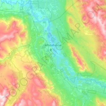
Name: Topografische Karte Whitehorse, Höhe, Relief.
Ort: Whitehorse, Yukon, Kanada (60.55364 -135.27872 60.84619 -134.85673)
Durchschnittliche Höhe: 1.007 m
Minimale Höhe: 629 m
Maximale Höhe: 1.857 m
Spenden
Rüste dich für dein nächstes Abenteuer:
Als Amazon-Partner verdient diese Website an qualifizierten Käufen, ohne zusätzliche Kosten für Sie.