
Spenden
Rüste dich für dein nächstes Abenteuer:
Als Amazon-Partner verdient diese Website an qualifizierten Käufen, ohne zusätzliche Kosten für Sie.
Topografische Karte Estes Park
Klicken Sie auf die Karte, um die Höhe anzuzeigen.
Spenden
Rüste dich für dein nächstes Abenteuer:
Als Amazon-Partner verdient diese Website an qualifizierten Käufen, ohne zusätzliche Kosten für Sie.
Estes Park
Die Stadt wurde nach Joel Estes benannt, der Estes Park 1859 gründete. Sie liegt in einem Tal in 2293 m Höhe über dem Meeresspiegel. Im Sommer ist sie ein beliebter Ausflugsort mit zahlreichen Touristengeschäften und Hauptzugang für den Rocky Mountain National Park.
Spenden
Rüste dich für dein nächstes Abenteuer:
Als Amazon-Partner verdient diese Website an qualifizierten Käufen, ohne zusätzliche Kosten für Sie.
Über diese Karte
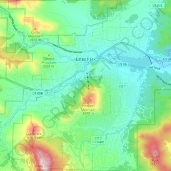
Name: Topografische Karte Estes Park, Höhe, Relief.
Durchschnittliche Höhe: 2.430 m
Minimale Höhe: 2.258 m
Maximale Höhe: 2.897 m
Spenden
Rüste dich für dein nächstes Abenteuer:
Als Amazon-Partner verdient diese Website an qualifizierten Käufen, ohne zusätzliche Kosten für Sie.
Andere topografische Karten
Klicken Sie auf eine Karte, um ihre Topografie, ihre Höhe und ihr Relief anzuzeigen.