
Topografische Karte Bastnach
Interaktive Karte
Klicken Sie auf die Karte, um die Höhe anzuzeigen.
Über diese Karte
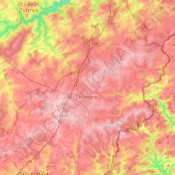
Name: Topografische Karte Bastnach, Höhe, Relief.
Ort: Bastnach, Bastogne, Luxemburg, Wallonien, 6600, Belgien (49.90936 5.63835 50.11722 5.86987)
Durchschnittliche Höhe: 465 m
Minimale Höhe: 284 m
Maximale Höhe: 562 m
Andere topografische Karten
Klicken Sie auf eine Karte, um ihre Topografie, ihre Höhe und ihr Relief anzuzeigen.