
Topografische Karte Lake Powell
Interaktive Karte
Klicken Sie auf die Karte, um die Höhe anzuzeigen.
Lake Powell
Mit der Fertigstellung des Glen Canyon Dams wurde der Glen Canyon ab dem 13. März 1963 vom Colorado überflutet und bis zum 22. Juni 1980 zum Lake Powell aufgestaut. Benannt wurde er nach dem Bürgerkriegsveteranen Major John Wesley Powell, der im August 1869 mit acht weiteren Männern den Glen Canyon erforschte. Heute ist der See nach dem Lake Mead (Nevada/Arizona) der zweitgrößte Stausee der Vereinigten Staaten. Bei maximaler Stauhöhe hat er eine Länge von rund 300 km, ist am Damm 171 m tief und bedeckt eine Fläche von 653 km² (auf Seespiegelhöhe von 3700 Fuß – 1127,76 m). Mit rund 33,3 Mrd. m³ (= 33,3 km³) Wasser überflutet der Lake Powell dann 96 Canyons und erstreckt sich weit in die Mündungen des von Nordwesten her kommenden Escalante River sowie des von Osten her kommenden San Juan River. Die Küstenlinie des Sees ist mit 3153 km (1960 Meilen) länger als die gesamte Westküste der USA.
Über diese Karte
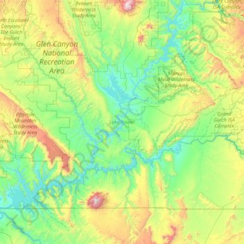
Name: Topografische Karte Lake Powell, Höhe, Relief.
Durchschnittliche Höhe: 1.555 m
Minimale Höhe: 1.103 m
Maximale Höhe: 3.236 m
Andere topografische Karten
Klicken Sie auf eine Karte, um ihre Topografie, ihre Höhe und ihr Relief anzuzeigen.
Goulding's / Tségiizh
Vereinigte Staaten von Amerika > Utah > San Juan County
Durchschnittliche Höhe: 1.634 m
Colorado-Plateau
Vereinigte Staaten von Amerika > Utah > San Juan County
Das Gestein des Colorado-Plateaus ist in Schichten aufgebaut. Die ältesten Schichten treten in der inneren Schlucht des Grand Canyon zu Tage, etwa auf 730 m Höhe. Sie sind 600 bis über 2000 Millionen Jahre alt und stammen aus der Zeit des Präkambrium.
Durchschnittliche Höhe: 1.512 m