
Topografische Karte Johannisbad
Interaktive Karte
Klicken Sie auf die Karte, um die Höhe anzuzeigen.
Johannisbad
Die Kleinstadt liegt auf einer mittleren Höhe von 519 m n.m. in einem Nebental des Flusses Úpa (Aupa). Nächste Stadt und Bahnstation ist das drei Kilometer östlich gelegene Svoboda nad Úpou. Hausberg von Janské Lázně ist der Černá hora (Schwarzenberg) mit 1299 m n.m.
Über diese Karte
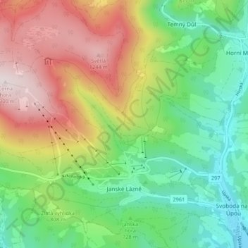
Name: Topografische Karte Johannisbad, Höhe, Relief.
Durchschnittliche Höhe: 821 m
Minimale Höhe: 505 m
Maximale Höhe: 1.303 m