
Topografische Karte Obergoms
Interaktive Karte
Klicken Sie auf die Karte, um die Höhe anzuzeigen.
Über diese Karte
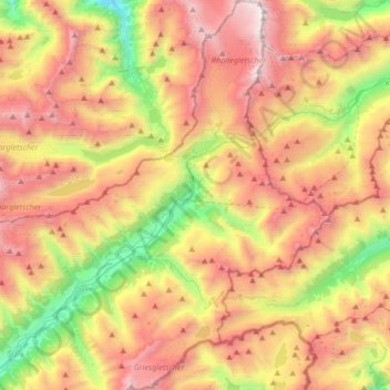
Name: Topografische Karte Obergoms, Höhe, Relief.
Ort: Obergoms, Goms, Wallis, Schweiz (46.42362 8.25806 46.65405 8.47856)
Durchschnittliche Höhe: 2.306 m
Minimale Höhe: 1.068 m
Maximale Höhe: 3.593 m
Andere topografische Karten
Klicken Sie auf eine Karte, um ihre Topografie, ihre Höhe und ihr Relief anzuzeigen.
Grosser Aletschgletscher
Schweiz > Wallis > Goms > Fieschertal
Vom Konkordiaplatz aus bewegt sich der Eisstrom mit einer Breite von ungefähr 1,5 km und mit einer Geschwindigkeit von bis zu 180 Metern pro Jahr nach Südosten in Richtung Rhonetal, gesäumt vom Dreieckhorn im Westen und dem Gross Wannenhorn im Osten. Er zeichnet dann eine grosse Rechtskurve und biegt immer…
Durchschnittliche Höhe: 2.532 m
Grosser Aletschgletscher
Schweiz > Wallis > Goms > Fieschertal
Vom Konkordiaplatz aus bewegt sich der Eisstrom mit einer Breite von ungefähr 1,5 km und mit einer Geschwindigkeit von bis zu 180 Metern pro Jahr nach Südosten in Richtung Rhonetal, gesäumt vom Dreieckhorn im Westen und dem Grossen Wannenhorn im Osten. Er zeichnet dann eine grosse Rechtskurve und biegt…
Durchschnittliche Höhe: 2.532 m
Mönch
Schweiz > Wallis > Goms > Fieschertal
1935 wurde die Höhe des Mönchs mit 4099 m bestimmt. Diese Zahl ist noch heute häufig in der Literatur zu finden. 1993 ergaben jedoch Messungen per Luftfotogrammetrie eine Höhe von 4107 m. Daraufhin wurde der Wert auf der Landeskarte der Schweiz korrigiert. Mit einer Messung per GPS ermittelte man 1997 eine…
Durchschnittliche Höhe: 3.392 m