
Topografische Karte เกาะพะงัน
Interaktive Karte
Klicken Sie auf die Karte, um die Höhe anzuzeigen.
Über diese Karte
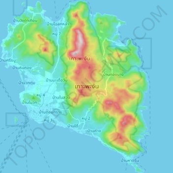
Name: Topografische Karte เกาะพะงัน, Höhe, Relief.
Ort: เกาะพะงัน, Ko Pha-Ngan, Surat Thani, Thailand (9.66567 99.96074 9.80402 100.08177)
Durchschnittliche Höhe: 84 m
Minimale Höhe: 0 m
Maximale Höhe: 602 m
Andere topografische Karten
Klicken Sie auf eine Karte, um ihre Topografie, ihre Höhe und ihr Relief anzuzeigen.