
Topografische Karte Genf
Interaktive Karte
Klicken Sie auf die Karte, um die Höhe anzuzeigen.
Genf
Die Jahresmitteltemperatur für die Normalperiode 1991 bis 2020 beträgt 11,0 Grad Celsius, wobei im Januar mit 2,1 Grad Celsius die kältesten und im Juli mit 20,6 Grad Celsius die wärmsten Monatsmitteltemperaturen gemessen werden. Im Mittel sind hier rund 73 Frosttage und 7 Eistage zu erwarten. Sommertage gibt es im Jahresmittel rund 64, während normalerweise 17 bis 18 Hitzetage zu verzeichnen sind. Die Wetterstation von MeteoSchweiz liegt auf einer Höhe von 411 m ü. M. am Flughafen Genf, ca. 6 Kilometer vom Stadtzentrum entfernt (Luftlinie).
Über diese Karte
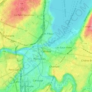
Name: Topografische Karte Genf, Höhe, Relief.
Ort: Genf, Schweiz (46.17777 6.11024 46.23189 6.17585)
Durchschnittliche Höhe: 404 m
Minimale Höhe: 367 m
Maximale Höhe: 474 m
Andere topografische Karten
Klicken Sie auf eine Karte, um ihre Topografie, ihre Höhe und ihr Relief anzuzeigen.
Genf
Die Jahresmitteltemperatur für die Normalperiode 1991–2020 beträgt 11,0 °C, wobei im Januar mit 2,1 °C die kältesten und im Juli mit 20,6 °C die wärmsten Monatsmitteltemperaturen gemessen werden. Im Mittel sind hier rund 73 Frosttage und 7 Eistage zu erwarten. Sommertage gibt es im Jahresmittel rund…
Durchschnittliche Höhe: 608 m