
Topografische Karte Ojén
Interaktive Karte
Klicken Sie auf die Karte, um die Höhe anzuzeigen.
Ojén
Der Ort Ojén liegt im Süden der zumeist bewaldeten Berge der Sierra de las Nieves, einem Teil der Betischen Kordillere, knapp 55 km (Fahrtstrecke) westlich der Provinzhauptstadt Málaga in einer Höhe von ca. 290 bis 310 m; die Stadt Marbella ist nur ca. 9 km in südlicher Richtung entfernt. Das gleichermaßen vom Atlantik wie vom Mittelmeer beeinflusste Klima ist gemäßigt bis warm; der für südspanische Verhältnisse ergiebige Regen (ca. 635 mm/Jahr) fällt – mit Ausnahme der nahezu regenlosen Sommermonate – übers Jahr verteilt.
Über diese Karte
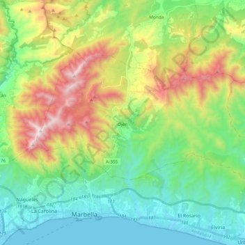
Name: Topografische Karte Ojén, Höhe, Relief.
Ort: Ojén, Sierra de las Nieves, Málaga, Andalusien, 29610, Spanien (36.52108 -4.92218 36.60949 -4.73540)
Durchschnittliche Höhe: 404 m
Minimale Höhe: -1 m
Maximale Höhe: 1.254 m