
Topografische Karte Sinaia
Interaktive Karte
Klicken Sie auf die Karte, um die Höhe anzuzeigen.
Sinaia
Sinaia liegt in den Südkarpaten im Tal des Flusses Prahova. Um die Kleinstadt liegt ein beliebtes Skigebiet, das Bucegi-Gebirge. Von Sinaia (767–860 m) führt eine Seilbahn bis auf eine Höhe von 2000 m, außerdem gibt es mehrere Skilifte. An der Bahnstrecke Ploiești–Brașov gelegen, halten hier sämtliche Regional-, Interregio- und Intercity-Züge von und nach Prag bzw. Wien. An der Europastraße 60 befindet sich Sinaia 44 Kilometer südlich von Brașov (Kronstadt) und 65 Kilometer nordwestlich von der Kreishauptstadt Ploiești entfernt.
Über diese Karte
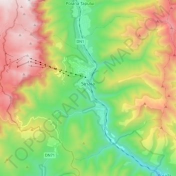
Name: Topografische Karte Sinaia, Höhe, Relief.
Ort: Sinaia, Prahova, 106100, Rumänien (45.29640 25.46770 45.38861 25.62769)
Durchschnittliche Höhe: 1.249 m
Minimale Höhe: 649 m
Maximale Höhe: 2.141 m
Andere topografische Karten
Klicken Sie auf eine Karte, um ihre Topografie, ihre Höhe und ihr Relief anzuzeigen.
Sinaia
Sinaia liegt in den Südkarpaten im Tal des Flusses Prahova. Um die Kleinstadt liegt ein beliebtes Skigebiet, das Bucegi-Gebirge. Von Sinaia (767–860 m) führt eine Seilbahn bis auf eine Höhe von 2000 m, außerdem gibt es mehrere Skilifte. An der Bahnstrecke Ploiești–Brașov gelegen, halten hier…
Durchschnittliche Höhe: 1.098 m