
Spenden
Rüste dich für dein nächstes Abenteuer:
Als Amazon-Partner verdient diese Website an qualifizierten Käufen, ohne zusätzliche Kosten für Sie.
Topografische Karte Potsdam
Klicken Sie auf die Karte, um die Höhe anzuzeigen.
Spenden
Rüste dich für dein nächstes Abenteuer:
Als Amazon-Partner verdient diese Website an qualifizierten Käufen, ohne zusätzliche Kosten für Sie.
Potsdam
In Potsdam herrscht ein gemäßigtes Klima, das sowohl von Norden und Westen her vom atlantischen Klima als auch vom kontinentalen Klima aus Osten beeinflusst wird. Wetterextreme wie Stürme, starker Hagel oder starke Schneefälle sind selten. Der Temperaturverlauf entspricht ungefähr dem bundesdeutschen Durchschnitt. Die jahreszeitlichen Temperaturschwankungen sind geringer als im üblichen kontinentalen Klima, aber höher als im ausgeglicheneren Meeresklima der Küstenregionen. Die Niederschlagsmenge ist mit einer Jahressumme von 590 Millimetern relativ gering. So liegt diese zum Beispiel in Barcelona ebenfalls bei 590 Millimetern, in München hingegen bei etwa 1000 Millimetern. Seit Beginn der Aufzeichnungen erlebte Potsdam ungefähr jedes vierte Jahr weiße Weihnachten und im Jahr 2010 mit der größten Schneehöhe von 23 cm.
Spenden
Rüste dich für dein nächstes Abenteuer:
Als Amazon-Partner verdient diese Website an qualifizierten Käufen, ohne zusätzliche Kosten für Sie.
Über diese Karte
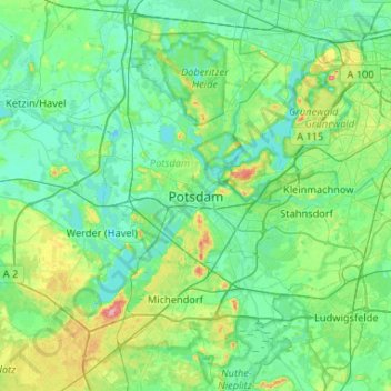
Name: Topografische Karte Potsdam, Höhe, Relief.
Ort: Potsdam, Brandenburg, 14467, Deutschland (52.24093 12.89914 52.56093 13.21914)
Durchschnittliche Höhe: 43 m
Minimale Höhe: 25 m
Maximale Höhe: 121 m
Spenden
Rüste dich für dein nächstes Abenteuer:
Als Amazon-Partner verdient diese Website an qualifizierten Käufen, ohne zusätzliche Kosten für Sie.
Andere topografische Karten
Klicken Sie auf eine Karte, um ihre Topografie, ihre Höhe und ihr Relief anzuzeigen.
Eiche
Deutschland > Brandenburg > Potsdam
1680 waren die acht Hufen in 16 kleinere Hufen geteilt worden. Nach einer Notiz von 1708 scheint sich diese Hufenteilung nicht durchgesetzt zu haben. Es gab drei Bauerngüter im Dorf, die je zwei Hufen beackerten. Ein Bauernhof mit zwei Hufen war unbesetzt. Das Feld wurde aber von zwei Halbkossäten genutzt.…
Durchschnittliche Höhe: 39 m
Neu Fahrland
Deutschland > Brandenburg > Potsdam
Neu Fahrland liegt im Norden von Potsdam und wird von der B 2 durchschnitten. Der Ortsteil grenzt im Norden an die Potsdamer Ortsteile Fahrland und Krampnitz. Im Uhrzeigersinn wird der Ortsteil im Osten durch den Krampnitzsee und den Lehnitzsee begrenzt, im Süden durch den Jungfernsee, den Sacrow-Paretzer…
Durchschnittliche Höhe: 38 m
Spenden
Rüste dich für dein nächstes Abenteuer:
Als Amazon-Partner verdient diese Website an qualifizierten Käufen, ohne zusätzliche Kosten für Sie.
Spenden
Rüste dich für dein nächstes Abenteuer:
Als Amazon-Partner verdient diese Website an qualifizierten Käufen, ohne zusätzliche Kosten für Sie.