
Topografische Karte Bloemfontein
Interaktive Karte
Klicken Sie auf die Karte, um die Höhe anzuzeigen.
Bloemfontein
Bloemfontein hat ein subtropisches Höhenklima (Klimaklassifikation nach Köppen und Geiger: Cwa). Der Winter dauert in Bloemfontein von Mai bis August, der Sommer umfasst die Monate Oktober bis Februar. Die Wintermonate sind mit mittleren Niederschlägen von weniger als 30 mm trocken. Hier erreichen die Tageshöchsttemperaturen Werte von 16 °C bis 20 °C, die mittleren nächtlichen Tiefstwerte reichen bis zum Gefrierpunkt, wobei Nachtfrost keine Seltenheit darstellt. In den Sommermonaten kommt es häufig zu Wolkenbrüchen, die mittleren monatlichen Niederschläge liegen zwischen 50 mm und über 100 mm. Die Tageshöchsttemperaturen erreichen im Hochsommer mittlere Werte von knapp über 30 °C, die täglichen Tiefstwerte im Mittel etwa 16 °C.
Über diese Karte
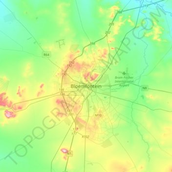
Name: Topografische Karte Bloemfontein, Höhe, Relief.
Durchschnittliche Höhe: 1.374 m
Minimale Höhe: 1.283 m
Maximale Höhe: 1.593 m