
Spenden
Rüste dich für dein nächstes Abenteuer:
Als Amazon-Partner verdient diese Website an qualifizierten Käufen, ohne zusätzliche Kosten für Sie.
Topografische Karte Dharamsala
Klicken Sie auf die Karte, um die Höhe anzuzeigen.
Spenden
Rüste dich für dein nächstes Abenteuer:
Als Amazon-Partner verdient diese Website an qualifizierten Käufen, ohne zusätzliche Kosten für Sie.
Dharamsala
Dharamsala ist aufgeteilt in das wirtschaftliche Zentrum Lower Dharamsala (auch Kotwali Bazaar u. a., 1280 m) und das ca. 5 km (Luftlinie), aber ca. 15 km Fahrtstrecke nördlich gelegene Pilgerzentrum Upper Dharamsala (auch McLeod Ganj, 1830 m). Aufgrund der Höhendifferenz liegen beide Ortsteile getrennt. Für kleinere Fahrzeuge (Riksha, Minivan, Jeep) und Fußgänger besteht eine etwa 2 km lange direkte, aber steile Verbindung; Pkw, Lkw und Busse müssen eine rund 9 km lange, kurvenreiche Straße zwischen den Teilorten benutzen.
Spenden
Rüste dich für dein nächstes Abenteuer:
Als Amazon-Partner verdient diese Website an qualifizierten Käufen, ohne zusätzliche Kosten für Sie.
Über diese Karte
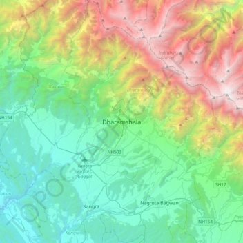
Name: Topografische Karte Dharamsala, Höhe, Relief.
Durchschnittliche Höhe: 1.781 m
Minimale Höhe: 485 m
Maximale Höhe: 4.909 m
Spenden
Rüste dich für dein nächstes Abenteuer:
Als Amazon-Partner verdient diese Website an qualifizierten Käufen, ohne zusätzliche Kosten für Sie.