
Spenden
Rüste dich für dein nächstes Abenteuer:
Als Amazon-Partner verdient diese Website an qualifizierten Käufen, ohne zusätzliche Kosten für Sie.
Topografische Karte Colorado Springs
Klicken Sie auf die Karte, um die Höhe anzuzeigen.
Spenden
Rüste dich für dein nächstes Abenteuer:
Als Amazon-Partner verdient diese Website an qualifizierten Käufen, ohne zusätzliche Kosten für Sie.
Über diese Karte
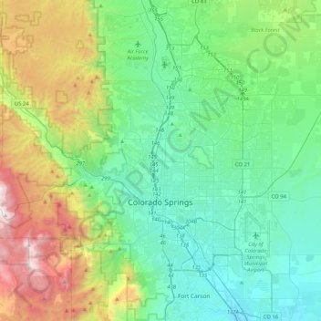
Name: Topografische Karte Colorado Springs, Höhe, Relief.
Durchschnittliche Höhe: 2.252 m
Minimale Höhe: 1.708 m
Maximale Höhe: 3.853 m
Spenden
Rüste dich für dein nächstes Abenteuer:
Als Amazon-Partner verdient diese Website an qualifizierten Käufen, ohne zusätzliche Kosten für Sie.
Andere topografische Karten
Klicken Sie auf eine Karte, um ihre Topografie, ihre Höhe und ihr Relief anzuzeigen.
Pikes Peak
Vereinigte Staaten von Amerika > Colorado > El Paso County
Pikes Peak (früher Pike’s Peak) ist ein Berg mit einer Höhe von 4301 m (14.110 Fuß) in der Front Range der Rocky Mountains, nahe Colorado Springs, Colorado. Er wurde benannt nach Zebulon Pike, einem Forschungsreisenden, der 1806 die Pike-Expedition in das südliche Colorado anführte. Es handelt sich um…
Durchschnittliche Höhe: 3.902 m
Colorado Springs
Vereinigte Staaten von Amerika > Colorado > El Paso County
Durchschnittliche Höhe: 2.229 m
Point Sublime
Vereinigte Staaten von Amerika > Colorado > El Paso County > Colorado Springs
Durchschnittliche Höhe: 2.095 m
Spenden
Rüste dich für dein nächstes Abenteuer:
Als Amazon-Partner verdient diese Website an qualifizierten Käufen, ohne zusätzliche Kosten für Sie.