
Spenden
Rüste dich für dein nächstes Abenteuer:
Als Amazon-Partner verdient diese Website an qualifizierten Käufen, ohne zusätzliche Kosten für Sie.
Topografische Karte Aberystwyth
Klicken Sie auf die Karte, um die Höhe anzuzeigen.
Spenden
Rüste dich für dein nächstes Abenteuer:
Als Amazon-Partner verdient diese Website an qualifizierten Käufen, ohne zusätzliche Kosten für Sie.
Aberystwyth
Das heutige Aberystwyth liegt an der gemeinsamen Mündung der Flüsse Rheidol und Ystwyth. Der Ystwyth floss eigentlich direkt in die Cardigan Bay, wurde aber im Mittelalter zum Rheidol hin umgelenkt, um dessen Wassermenge zu erhöhen und auf diese Weise eine unterseeische Behinderung am Hafeneingang wegzuschwemmen. Der Hafen, jetzt eigentlich kaum noch genutzt, war einst wichtiger Anlaufpunkt für die Küstenschifffahrt, für Schifffahrtslinien nach Irland und sogar für transatlantische Verbindungen (zum Beispiel schifften sich hier walisische Emigranten für die Überfahrt nach Nordamerika ein). Außerdem diente er als Seehafen für die einst florierenden Bleiminen von Cardiganshire.
Spenden
Rüste dich für dein nächstes Abenteuer:
Als Amazon-Partner verdient diese Website an qualifizierten Käufen, ohne zusätzliche Kosten für Sie.
Über diese Karte
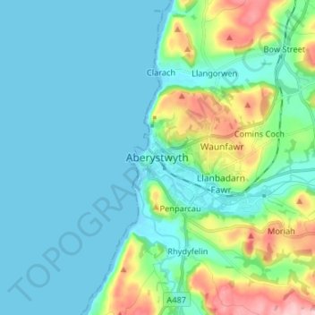
Name: Topografische Karte Aberystwyth, Höhe, Relief.
Durchschnittliche Höhe: 39 m
Minimale Höhe: -1 m
Maximale Höhe: 195 m
Spenden
Rüste dich für dein nächstes Abenteuer:
Als Amazon-Partner verdient diese Website an qualifizierten Käufen, ohne zusätzliche Kosten für Sie.