
Topografische Karte Lavamünd
Interaktive Karte
Klicken Sie auf die Karte, um die Höhe anzuzeigen.
Lavamünd
Lavamünd liegt im Südosten von Kärnten auf einer Landzunge an der Mündung der Lavant in die Drau, die gleichzeitig die südliche Gemeindegrenze bildet. Die Höhe beträgt 348 m über dem Meer, womit Lavamünd der tiefste Punkt Kärntens ist. Um Lavamünd vor einem hundertjährlichen Hochwasser zu schützen, wurde am 16. Oktober 2018 mit dem Bau einer 1,5 km langen Schutzmauer begonnen, es werden auch zwei Brücken über die Lavant neu gebaut, damit soll es keine Verklausungen mehr geben. Bis 2023 soll der Hochwasserschutz fertiggestellt sein.
Über diese Karte
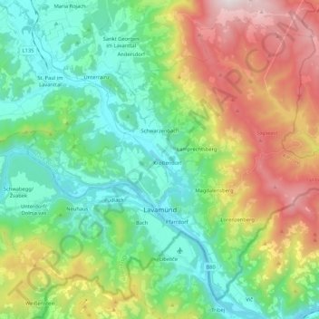
Name: Topografische Karte Lavamünd, Höhe, Relief.
Ort: Lavamünd, Bezirk Wolfsberg, Kärnten, 9473, Österreich (46.60140 14.85436 46.72871 15.06515)
Durchschnittliche Höhe: 768 m
Minimale Höhe: 326 m
Maximale Höhe: 1.688 m
Andere topografische Karten
Klicken Sie auf eine Karte, um ihre Topografie, ihre Höhe und ihr Relief anzuzeigen.
Loschental
Österreich > Kärnten > Bezirk Wolfsberg > Sankt Paul im Lavanttal
Durchschnittliche Höhe: 487 m
Michaelsdorf
Österreich > Kärnten > Bezirk Wolfsberg > Wolfsberg > Paildorf
Durchschnittliche Höhe: 584 m
Kamp
Österreich > Kärnten > Bezirk Wolfsberg > Frantschach-Sankt Gertraud
Durchschnittliche Höhe: 1.090 m
Vorderwölch
Österreich > Kärnten > Bezirk Wolfsberg > Frantschach-Sankt Gertraud > Zellach
Durchschnittliche Höhe: 658 m
Paierdorf
Österreich > Kärnten > Bezirk Wolfsberg > Sankt Andrä > Gemmersdorf
Durchschnittliche Höhe: 561 m
Twimberg
Österreich > Kärnten > Bezirk Wolfsberg > Bad Sankt Leonhard im Lavanttal
Durchschnittliche Höhe: 791 m
Hintergumitsch
Österreich > Kärnten > Bezirk Wolfsberg > Frantschach-Sankt Gertraud
Durchschnittliche Höhe: 662 m
St. Paul im Lavanttal
Österreich > Kärnten > Bezirk Wolfsberg > Sankt Paul im Lavanttal
Durchschnittliche Höhe: 466 m
Messensach
Österreich > Kärnten > Bezirk Wolfsberg > Sankt Andrä > Jakling
Durchschnittliche Höhe: 426 m
Schiefling
Österreich > Kärnten > Bezirk Wolfsberg > Bad Sankt Leonhard im Lavanttal
Durchschnittliche Höhe: 849 m
Steinberg-Oberhaus
Österreich > Kärnten > Bezirk Wolfsberg > Sankt Georgen im Lavanttal
Durchschnittliche Höhe: 850 m
Frantschach
Österreich > Kärnten > Bezirk Wolfsberg > Frantschach-Sankt Gertraud
Durchschnittliche Höhe: 717 m
Schönweg - Sankt Andrä
Österreich > Kärnten > Bezirk Wolfsberg > Sankt Andrä
Durchschnittliche Höhe: 565 m
Schönberg
Österreich > Kärnten > Bezirk Wolfsberg > Bad Sankt Leonhard im Lavanttal > Schönberg
Durchschnittliche Höhe: 1.033 m
Soboth
Österreich > Kärnten > Bezirk Wolfsberg > Lavamünd
Die Soboth ist eine Passstraße an den südwestlichen Ausläufern der Koralpe (Slowenisch: Golica), in der Nähe des Dreiländerecks Kärnten-Steiermark-Slowenien, deren höchste Stelle Koglereck sich auf einer Höhe von 1347 m ü. A. befindet. Die besonders bei Motorradfahrern beliebte Bergstrecke führt,…
Durchschnittliche Höhe: 1.231 m
Stadling
Österreich > Kärnten > Bezirk Wolfsberg > Sankt Paul im Lavanttal > Stadling
Durchschnittliche Höhe: 436 m
Sommerau
Österreich > Kärnten > Bezirk Wolfsberg > Reichenfels > Sommerau
Durchschnittliche Höhe: 1.382 m