
Topografische Karte Evolène
Interaktive Karte
Klicken Sie auf die Karte, um die Höhe anzuzeigen.
Evolène
Für die Normalperiode 1991–2020 beträgt die Jahresmitteltemperatur 4,5 °C, wobei im Februar mit −2,8 °C die kältesten und im Juli mit 12,7 °C die wärmsten Monatsmitteltemperaturen gemessen werden. Im Mittel sind hier rund 159 Frosttage und 50 Eistage zu erwarten. Sommertage gibt es im Durchschnitt 1,8. Die Messstation von MeteoSchweiz liegt auf einer Höhe von 1825 m ü. M. an Südhang nahe dem Dorf Villa, ca. 450 m höher gelegen als der Dorfkern von Evolène.
Über diese Karte
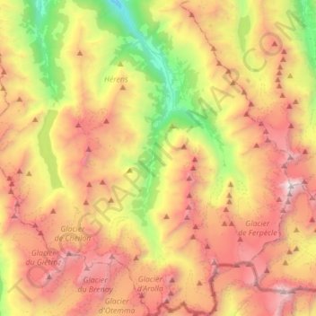
Name: Topografische Karte Evolène, Höhe, Relief.
Ort: Evolène, Ering, Wallis, 1983, Schweiz (45.95490 7.42553 46.14706 7.61195)
Durchschnittliche Höhe: 2.697 m
Minimale Höhe: 1.129 m
Maximale Höhe: 4.350 m
Andere topografische Karten
Klicken Sie auf eine Karte, um ihre Topografie, ihre Höhe und ihr Relief anzuzeigen.