Geolokalisieren

Topografische Karte Kaliabor

Interaktive Karte

Klicken Sie auf die Karte, um die Höhe anzuzeigen.

Über diese Karte

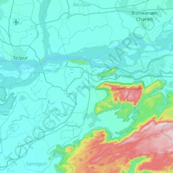
Name: Topografische Karte Kaliabor, Höhe, Relief.

Ort: Kaliabor, Nagaon, Assam, India (26.39789 92.82924 26.69996 93.31905)

Durchschnittliche Höhe: 152 m

Minimale Höhe: 54 m

Maximale Höhe: 802 m

Andere topografische Karten

Klicken Sie auf eine Karte, um ihre Topografie, ihre Höhe und ihr Relief anzuzeigen.

Guwahati

India > Assam > Guwahati

Professor Abani Kumar Bhagawati of Gauhati University stated that since before there were sufficient wetlands to absorb rainwater and channels to carry excess water to the Brahmaputra, the city did not experience floods. However, human interference has disrupted the natural topography, leading to the current…

Durchschnittliche Höhe: 113 m

Manja

India > Assam > Diphu

Durchschnittliche Höhe: 161 m

Tinsukia

India > Assam > Tinsukia

Tinsukia is located at 27°30′N 95°22′E / 27.5°N 95.37°E / 27.5; 95.37. It has an average elevation of 116 metres (380 feet).

Durchschnittliche Höhe: 123 m

Tumuki

India > Assam > Dhekiajuli (Pt)

Durchschnittliche Höhe: 70 m

Sivasagar

India > Assam > Sibsagar

Sivasagar is located at 27°09′N 95°15′E / 27.15°N 95.25°E / 27.15; 95.25. It has an average elevation of 86.6 meters above sea level.

Durchschnittliche Höhe: 93 m

Kamalabari

India > Assam > Majuli

Durchschnittliche Höhe: 84 m

Hollongapar Gibbon Sanctuary

India > Assam > Teok

Durchschnittliche Höhe: 113 m

Kohora

India > Assam > Bokakhat > Kohara

Durchschnittliche Höhe: 96 m

Gargaon Palace

India > Assam > Sonari > Sibsagar

Durchschnittliche Höhe: 97 m

Rajgorh

India > Assam > Gohpur

Durchschnittliche Höhe: 114 m

Fakiragram

India > Assam > Dotoma

Durchschnittliche Höhe: 41 m

Ranikhata

India > Assam > Bengtol

Durchschnittliche Höhe: 82 m

Bilasipara

India > Assam > Bilasipara Pt

Durchschnittliche Höhe: 34 m

Karigaon

India > Assam > Kokrajhar

Durchschnittliche Höhe: 62 m

Margherita

India > Assam > Margherita

Durchschnittliche Höhe: 160 m

Merapani

India > Assam > Golaghat

Durchschnittliche Höhe: 162 m

Duliajan

India > Assam > Tengakhat

Durchschnittliche Höhe: 121 m

Tinsukia

India > Assam > Tinsukia

Tinsukia is located at 27°30′N 95°22′E / 27.5°N 95.37°E / 27.5; 95.37. It has an average elevation of 116 metres (380 feet).

Durchschnittliche Höhe: 123 m

Sonari

India > Assam > Sonari

Sonari is located at 27°04′N 95°02′E / 27.07°N 95.03°E / 27.07; 95.03. It has an average elevation of 97 metres (318 feet). It is a major town on the nearly 500-year-old "Dhodar Ali" built by the Ahom Kings. Dhodar ali was forcefully commissioned by Ahom king Gadadhar Singha using the…

Durchschnittliche Höhe: 106 m

Kaziranga

India > Assam > Bokakhat > Kohara

Durchschnittliche Höhe: 93 m

Singri

India > Assam > Dhekiajuli (Pt)

Durchschnittliche Höhe: 68 m

Dhekiajuli

India > Assam > Dhekiajuli (Pt)

Durchschnittliche Höhe: 80 m

Dispur

India > Assam > Dispur

Durchschnittliche Höhe: 78 m

Jamugurihat

India > Assam > Na-Duar

Durchschnittliche Höhe: 72 m

Chutia

India > Assam > Na-Duar

Durchschnittliche Höhe: 73 m

Guwahati

India > Assam > Guwahati

Professor Abani Kumar Bhagawati of Gauhati University stated that since before there were sufficient wetlands to absorb rainwater and channels to carry excess water to the Brahmaputra, the city did not experience floods. However, human interference has disrupted the natural topography, leading to the current…

Durchschnittliche Höhe: 113 m

Sarupathar

India > Assam > Sarupathar

Durchschnittliche Höhe: 120 m

Sivasagar

India > Assam > Sibsagar

Sivasagar is located at 27°09′N 95°15′E / 27.15°N 95.25°E / 27.15; 95.25. It has an average elevation of 86.6 meters above sea level.

Durchschnittliche Höhe: 93 m

Karbi Anglong

India > Assam

Durchschnittliche Höhe: 437 m

Silapathar

India > Assam > Sissibargaon

Durchschnittliche Höhe: 114 m

Solmari

India > Assam > Balijana

Durchschnittliche Höhe: 43 m

Digaru

India > Assam > Sonapur > Sonapur

Durchschnittliche Höhe: 185 m

Golaghat

India > Assam > Golaghat

Golaghat is located at 26°31′N 93°58′E / 26.52°N 93.97°E / 26.52; 93.97. It has an average elevation of 95 metres (312 feet).

Durchschnittliche Höhe: 99 m

Tinsukia

India > Assam > Tinsukia

Tinsukia is located at 27°30′N 95°22′E / 27.5°N 95.37°E / 27.5; 95.37. It has an average elevation of 116 metres (380 feet).

Durchschnittliche Höhe: 123 m

Darrang

India > Assam

Durchschnittliche Höhe: 697 m

Hojai

India > Assam > Hojai

Durchschnittliche Höhe: 72 m

Hajua

India > Assam > Jalah (Pt)

Durchschnittliche Höhe: 54 m

Lido

India > Assam > Margherita

Durchschnittliche Höhe: 189 m

Marigaon

India > Assam > Marigaon

Durchschnittliche Höhe: 58 m

Chhaygaon

India > Assam > Chhaygaon

Durchschnittliche Höhe: 50 m

Barpeta

India > Assam > Barpeta

It is located at 26°19′N 91°00′E / 26.32°N 91.0°E / 26.32; 91.0. It has an average elevation of 35 metres (114 feet). It is 40 km away from Manas National Park. Three rivers - Chaulkhowa, Mora Nodi (Dead River) and Nakhanda, both of which are tributaries to Brahmaputra run through the town.

Durchschnittliche Höhe: 40 m

North Lakhimpur

India > Assam > North Lakhimpur

Durchschnittliche Höhe: 92 m

Nehru Park

India > Assam > Guwahati > Guwahati

Durchschnittliche Höhe: 53 m

Doom Dooma

India > Assam > Doom Dooma

Durchschnittliche Höhe: 128 m

Naharkatia

India > Assam > Naharkatiya

Durchschnittliche Höhe: 120 m

Jatinga

India > Assam > Haflong > Harangajao

Durchschnittliche Höhe: 619 m

Bokajan

India > Assam > Diphu

Durchschnittliche Höhe: 142 m

Udalguri

India > Assam > Udalguri tehsil

Odalguri is located at 26°44′43″N 92°05′46″E / 26.7452°N 92.0962°E / 26.7452; 92.0962. It has an average elevation of 180 metres (590 ft).

Durchschnittliche Höhe: 109 m

Nakhola

India > Assam > Mayong

Durchschnittliche Höhe: 103 m

Silchar

India > Assam > Silchar > Silchar

Durchschnittliche Höhe: 32 m

Barpeta Road

India > Assam > Barnagar (Pt)

Durchschnittliche Höhe: 46 m

Kopili

India > Assam > Kampur

Durchschnittliche Höhe: 76 m

Kāmrūp

India > Assam

Durchschnittliche Höhe: 330 m

Patacharkuchi

India > Assam > Tihu (Pt)

Durchschnittliche Höhe: 47 m

Dibrugarh

India > Assam > Dibrugarh East

Durchschnittliche Höhe: 106 m

Bordoloni

India > Assam > Gogamukh

Durchschnittliche Höhe: 96 m

Pagladia

India > Assam > Barbhag > Kamarkuchi

Durchschnittliche Höhe: 49 m

Titabor

India > Assam > Titabor

Durchschnittliche Höhe: 97 m

Sualkuchi

India > Assam > Hajo

Sualkuchi is located at 26°10′N 91°34′E / 26.17°N 91.57°E / 26.17; 91.57. It has an average elevation of 35 m (115 ft).

Durchschnittliche Höhe: 50 m

Jorabat

India > Assam > Sonapur

Durchschnittliche Höhe: 152 m

Jatinga

India > Assam > Silchar

Durchschnittliche Höhe: 156 m

Jorhat

India > Assam > Jorhat East

Jorhat is located at 26°45′N 94°13′E / 26.75°N 94.22°E / 26.75; 94.22. It has an average elevation of 116 metres (381 feet).

Durchschnittliche Höhe: 93 m

Burhi Dehing River

India > Assam > Margherita

Durchschnittliche Höhe: 162 m

Maligaon

India > Assam > Guwahati

Durchschnittliche Höhe: 71 m

Tezpur

India > Assam > Tezpur

Durchschnittliche Höhe: 68 m

Namrup

India > Assam > Naharkatiya > Namrup

Durchschnittliche Höhe: 133 m

Tipong;Lekhapani

India > Assam > Kamba

Durchschnittliche Höhe: 151 m

Nazira

India > Assam > Nazira > Nazira

Durchschnittliche Höhe: 97 m

Dimou

India > Assam > Dimou

Durchschnittliche Höhe: 61 m

Kamalabari

India > Assam > Kamalabari

Durchschnittliche Höhe: 59 m

Lohit

India > Assam

Durchschnittliche Höhe: 124 m

Goalpara

India > Assam > Balijana

Durchschnittliche Höhe: 48 m

Dibrugarh

India > Assam > Dibrugarh East

Durchschnittliche Höhe: 106 m

Subansiri

India > Assam

Durchschnittliche Höhe: 90 m

Moirabari

India > Assam > Moirabari

Durchschnittliche Höhe: 60 m

Nowgong

India > Assam

Durchschnittliche Höhe: 311 m

Mangaldoi

India > Assam > Mangaldoi (Pt)

Durchschnittliche Höhe: 58 m

Langting River

India > Assam

Durchschnittliche Höhe: 167 m

Jamuguri

India > Assam > Sibsagar > Jamuguri

Durchschnittliche Höhe: 94 m

Patgaon

India > Assam > Kokrajhar > Patgaon

Durchschnittliche Höhe: 67 m

Barangajuli

India > Assam > Harisinga > Barangajuli

Durchschnittliche Höhe: 117 m