
Topografische Karte Mayagüez
Interaktive Karte
Klicken Sie auf die Karte, um die Höhe anzuzeigen.
Mayagüez
Mayagüez has a tropical monsoon climate (Köppen climate classification Am). The city has the most extreme weather of the island. The high frequency of severe storms in the summer can produce strong winds, floods, waterspouts, and sometimes hail and even tornadoes. The average annual temperature is 75 °F (24 °C). Winter is usually quite dry and cool, with temperatures between 82 °F (28 °C) and 55 °F (13 °C). Summer is usually very hot and humid, with temperatures reaching 95 °F (35 °C), with heat index of up to 115 °F. From May to October, most evenings experience severe thunderstorms, due to heat, humidity and the topography of the area.
Über diese Karte
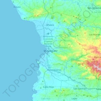
Name: Topografische Karte Mayagüez, Höhe, Relief.
Ort: Mayagüez, Puerto Rico, 00682, United States (18.04112 -67.29911 18.36112 -66.97911)
Durchschnittliche Höhe: 93 m
Minimale Höhe: 0 m
Maximale Höhe: 878 m
Andere topografische Karten
Klicken Sie auf eine Karte, um ihre Topografie, ihre Höhe und ihr Relief anzuzeigen.
Isla de Mona
United States > Puerto Rico > Mayagüez
Mona is a mainly flat plateau surrounded by sea cliffs. It is composed of dolomite and limestone with many caves found throughout. With an arid climate and untouched by human development, many endemic species inhabit the island, such as the Mona ground iguana (Cyclura cornuta stejnegeri). Its topography,…
Durchschnittliche Höhe: 26 m