
Topografische Karte Easter Island
Interaktive Karte
Klicken Sie auf die Karte, um die Höhe anzuzeigen.
Easter Island
The current Polynesian name of the island, Rapa Nui ("Big Rapa"), was coined after the slave raids of the early 1860s, and refers to the island's topographic resemblance to the island of Rapa in the Bass Islands of the Austral Islands group. However, Norwegian ethnographer Thor Heyerdahl argued that Rapa was the original name of Easter Island and that Rapa Iti was named by refugees from there.
Über diese Karte
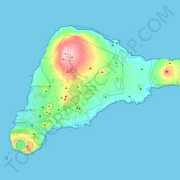
Name: Topografische Karte Easter Island, Höhe, Relief.
Durchschnittliche Höhe: 48 m
Minimale Höhe: 0 m
Maximale Höhe: 506 m
Andere topografische Karten
Klicken Sie auf eine Karte, um ihre Topografie, ihre Höhe und ihr Relief anzuzeigen.
Punta Roa
Chile > Valparaiso Region > Easter Island Province > Easter Island > Hanga Roa
Durchschnittliche Höhe: 11 m
Hanga Roa
Chile > Valparaiso Region > Easter Island Province > Easter Island
Durchschnittliche Höhe: 59 m
Hanga Roa
Chile > Valparaiso Region > Easter Island Province > Easter Island
Durchschnittliche Höhe: 59 m