
Topografische Karte Lane Cove National Park
Interaktive Karte
Klicken Sie auf die Karte, um die Höhe anzuzeigen.
Lane Cove National Park
The park includes areas of land which are part of Ku-ring-gai, Ryde, and Hornsby local government areas with small areas of the park in Willoughby, Lane Cove and Hunter's Hill local government areas on the banks of the lower reaches of the river. The park is surrounded on all sides by developed suburban areas and except for the upper northwestern region is never more than a kilometre wide. Much of the park is of fairly rugged terrain on the slopes of the river valley and covered by dense bush. The characteristics of the bush vary depending upon soils and topography. Parts of the park are affected by weed infestations, such as Fiddens Wharf and Fairyland.
Über diese Karte
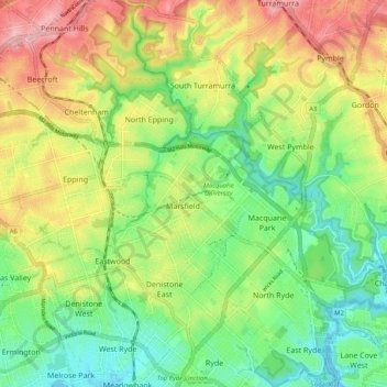
Name: Topografische Karte Lane Cove National Park, Höhe, Relief.
Durchschnittliche Höhe: 81 m
Minimale Höhe: -2 m
Maximale Höhe: 198 m
Andere topografische Karten
Klicken Sie auf eine Karte, um ihre Topografie, ihre Höhe und ihr Relief anzuzeigen.
George Kendall Park Dog Off-Leash Area
Australia > New South Wales > Sydney
Durchschnittliche Höhe: 15 m