
Topografische Karte Moselle
Interaktive Karte
Klicken Sie auf die Karte, um die Höhe anzuzeigen.
Über diese Karte
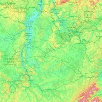
Name: Topografische Karte Moselle, Höhe, Relief.
Ort: Moselle, Grand Est, France métropolitaine, France (48.52656 5.89185 49.51494 7.63882)
Durchschnittliche Höhe: 289 m
Minimale Höhe: 141 m
Maximale Höhe: 1.017 m
Dans sa partie occidentale, le paysage est celui d'un plateau avec un mélange de terres agricoles et de collines boisées de faible altitude. Dans la partie orientale, le paysage est progressivement marqué par la forêt et un caractère plus montagnard, en tant que partie mosellane du massif des Vosges et des Vosges du Nord. Le point culminant de la Moselle est le Grossmann (986 m)
Andere topografische Karten
Klicken Sie auf eine Karte, um ihre Topografie, ihre Höhe und ihr Relief anzuzeigen.
Saint-Dizier
France > Grand Est > Haute-Marne
Saint-Dizier, Haute-Marne, Grand Est, France métropolitaine, 52100, France
Durchschnittliche Höhe: 163 m
Lichtenberg
Lichtenberg, Saverne, Bas-Rhin, Grand Est, France métropolitaine, 67340, France
Durchschnittliche Höhe: 279 m
Saint-Remy-sur-Bussy
Saint-Remy-sur-Bussy, Châlons-en-Champagne, Marne, Grand Est, France métropolitaine, 51600, France
Durchschnittliche Höhe: 162 m
Azelot
France > Grand Est > Meurthe-et-Moselle
Azelot, Nancy, Meurthe-et-Moselle, Grand Est, France métropolitaine, 54210, France
Durchschnittliche Höhe: 297 m
Meistratzheim
Meistratzheim, Sélestat-Erstein, Bas-Rhin, Grand Est, France métropolitaine, 67210, France
Durchschnittliche Höhe: 158 m
Rue du Moulin
France > Grand Est > Aube > Argançon
Rue du Moulin, Argançon, Bar-sur-Aube, Aube, Grand Est, France métropolitaine, 10140, France
Durchschnittliche Höhe: 215 m
Col de la Schlucht
France > Grand Est > Vosges > Le Valtin > La Schlucht
Col de la Schlucht, La Schlucht, Le Valtin, Saint-Dié-des-Vosges, Vosges, Grand Est, France métropolitaine, 88230, France
Durchschnittliche Höhe: 1.068 m
Bauzemont
France > Grand Est > Meurthe-et-Moselle
Bauzemont, Lunéville, Meurthe-et-Moselle, Grand Est, France métropolitaine, 54370, France
Durchschnittliche Höhe: 238 m
Maizières-lès-Metz
Maizières-lès-Metz, Metz, Moselle, Grand Est, France métropolitaine, 57280, France
Durchschnittliche Höhe: 172 m
Moutiers
France > Grand Est > Meurthe-et-Moselle
Moutiers, Val-de-Briey, Meurthe-et-Moselle, Grand Est, France métropolitaine, 54660, France
Durchschnittliche Höhe: 239 m
Mussey
France > Grand Est > Meuse > Bussy-la-Côte
Mussey, Bussy-la-Côte, Val-d'Ornain, Bar-le-Duc, Meuse, Grand Est, France métropolitaine, 55000, France
Durchschnittliche Höhe: 187 m
Sainte-Marguerite
Sainte-Marguerite, Saint-Dié-des-Vosges, Vosges, Grand Est, France métropolitaine, 88100, France
Durchschnittliche Höhe: 368 m
Noidant-le-Rocheux
France > Grand Est > Haute-Marne
Noidant-le-Rocheux, Langres, Haute-Marne, Grand Est, France métropolitaine, 52200, France
Durchschnittliche Höhe: 438 m
Strasbourg
Strasbourg, Bas-Rhin, Grand Est, France métropolitaine, France
Durchschnittliche Höhe: 144 m
Longeville-lès-Saint-Avold
Longeville-lès-Saint-Avold, Forbach-Boulay-Moselle, Moselle, Grand Est, France métropolitaine, 57740, France
Durchschnittliche Höhe: 304 m
Saint-Nicolas-la-Chapelle
Saint-Nicolas-la-Chapelle, Nogent-sur-Seine, Aube, Grand Est, France métropolitaine, 10400, France
Durchschnittliche Höhe: 91 m
Chemin de la Chaussée
France > Grand Est > Marne > Saint-Jean-sur-Moivre
Chemin de la Chaussée, Saint-Jean-sur-Moivre, Châlons-en-Champagne, Marne, Grand Est, France métropolitaine, 51240, France
Durchschnittliche Höhe: 131 m
Ligny-en-Barrois
Ligny-en-Barrois, Bar-le-Duc, Meuse, Grand Est, France métropolitaine, 55500, France
Durchschnittliche Höhe: 308 m
Tournavaux
Tournavaux, Charleville-Mézières, Ardennes, Grand Est, France métropolitaine, 08800, France
Durchschnittliche Höhe: 227 m
Voie des Brebis
France > Grand Est > Aube > Cussangy
Voie des Brebis, Cussangy, Troyes, Aube, Grand Est, France métropolitaine, 10210, France
Durchschnittliche Höhe: 187 m
Lay-Saint-Christophe
France > Grand Est > Meurthe-et-Moselle
Lay-Saint-Christophe, Nancy, Meurthe-et-Moselle, Grand Est, France métropolitaine, 54690, France
Durchschnittliche Höhe: 282 m
Laneuveville-devant-Bayon
France > Grand Est > Meurthe-et-Moselle
Laneuveville-devant-Bayon, Nancy, Meurthe-et-Moselle, Grand Est, France métropolitaine, 54740, France
Durchschnittliche Höhe: 319 m
Villers-lès-Nancy
France > Grand Est > Meurthe-et-Moselle
Villers-lès-Nancy, Nancy, Meurthe-et-Moselle, Grand Est, France métropolitaine, 54600, France
Durchschnittliche Höhe: 307 m
Stre.
France > Grand Est > Bas-Rhin > Oberlauterbach
Stre., Oberlauterbach, Haguenau-Wissembourg, Bas-Rhin, Grand Est, France métropolitaine, 67160, France
Durchschnittliche Höhe: 171 m
Orschwiller
Orschwiller, Sélestat-Erstein, Bas-Rhin, Grand Est, France métropolitaine, 67600, France
Durchschnittliche Höhe: 271 m
Châtel-Saint-Germain
Châtel-Saint-Germain, Metz, Moselle, Grand Est, France métropolitaine, 57160, France
Durchschnittliche Höhe: 293 m
Le Syndicat
Le Syndicat, Saint-Dié-des-Vosges, Vosges, Grand Est, France métropolitaine, 88120, France
Durchschnittliche Höhe: 547 m
Rigny-le-Ferron
Rigny-le-Ferron, Troyes, Aube, Grand Est, France métropolitaine, 10160, France
Durchschnittliche Höhe: 168 m
Provenchères-sur-Fave
France > Grand Est > Vosges > Provenchères-et-Colroy
Provenchères-sur-Fave, Provenchères-et-Colroy, Saint-Dié-des-Vosges, Vosges, Grand Est, France métropolitaine, 88490, France
Durchschnittliche Höhe: 452 m
Hagenthal-le-Bas
France > Grand Est > Haut-Rhin
Hagenthal-le-Bas, Mulhouse, Haut-Rhin, Grand Est, France métropolitaine, 68220, France
Durchschnittliche Höhe: 395 m
Fronville
France > Grand Est > Haute-Marne
Fronville, Saint-Dizier, Haute-Marne, Grand Est, France métropolitaine, 52300, France
Durchschnittliche Höhe: 250 m
Bar-le-Duc
Bar-le-Duc, Meuse, Grand Est, France métropolitaine, 55000, France
Durchschnittliche Höhe: 253 m