
Topografische Karte Sanjay Gandhi (Borivilli) National Park
Interaktive Karte
Klicken Sie auf die Karte, um die Höhe anzuzeigen.
Sanjay Gandhi (Borivilli) National Park
The region is hilly with elevations between 30 and 480 m (98 and 1,575 ft). The park has two lakes, Vihar Lake and Tulsi Lake, which meet a part of the city's water requirements. The park is said to be the lungs of the city as it purifies much of the air pollution of the city.
Über diese Karte
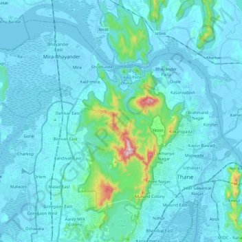
Name: Topografische Karte Sanjay Gandhi (Borivilli) National Park, Höhe, Relief.
Durchschnittliche Höhe: 42 m
Minimale Höhe: -4 m
Maximale Höhe: 479 m