Geolokalisieren

Topografische Karte Newport

Interaktive Karte

Klicken Sie auf die Karte, um die Höhe anzuzeigen.

Newport

In 1880, Canadian-born entrepreneur Alexander Arthur (1846–1912), representing the Scottish Carolina Timber and Land Company, arrived in Newport with ambitious plans to log the Pigeon valley. Arthur's plan called for the construction of a series of dams and booms which would be used to move logs from the higher elevations downstream using the river's current. The logs would eventually be floated all the way to Knoxville. The operation would be based in Newport, with a sawmill in the higher elevations at Pigeon Valley (now Hartford, Tennessee).

Wikipedia (CC-BY-SA 3.0)

Über diese Karte

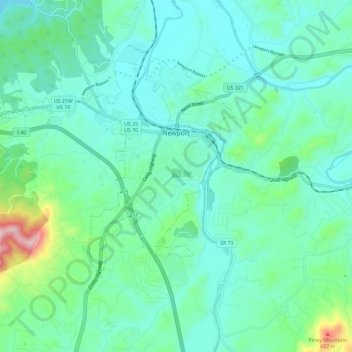
Name: Topografische Karte Newport, Höhe, Relief.

Ort: Newport, Cocke County, East Tennessee, Tennessee, 37821, United States (35.92379 -83.28133 35.98697 -83.16513)

Durchschnittliche Höhe: 372 m

Minimale Höhe: 290 m

Maximale Höhe: 728 m

Andere topografische Karten

Klicken Sie auf eine Karte, um ihre Topografie, ihre Höhe und ihr Relief anzuzeigen.

Cosby

United States > Tennessee > Cocke County

Durchschnittliche Höhe: 483 m

Bybee

United States > Tennessee > Cocke County

Durchschnittliche Höhe: 349 m

Bybee

United States > Tennessee > Cocke County

Durchschnittliche Höhe: 349 m

Cosby

United States > Tennessee > Cocke County

Durchschnittliche Höhe: 483 m

Jaybird

United States > Tennessee > Cocke County > Newport

Durchschnittliche Höhe: 348 m

Solomon Island

United States > Tennessee > Cocke County

Durchschnittliche Höhe: 422 m

English Mountain

United States > Tennessee > Cocke County

Durchschnittliche Höhe: 895 m

Del Rio

United States > Tennessee > Cocke County

Durchschnittliche Höhe: 405 m

Del Rio

United States > Tennessee > Cocke County

Durchschnittliche Höhe: 405 m

London

United States > Tennessee > Cocke County

Durchschnittliche Höhe: 515 m