Geolokalisieren

Topografische Karte Pope County

Interaktive Karte

Klicken Sie auf die Karte, um die Höhe anzuzeigen.

Über diese Karte

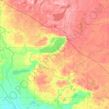
Name: Topografische Karte Pope County, Höhe, Relief.

Ort: Pope County, Minnesota, United States (45.41216 -95.75945 45.75999 -95.13173)

Durchschnittliche Höhe: 385 m

Minimale Höhe: 315 m

Maximale Höhe: 457 m

Andere topografische Karten

Klicken Sie auf eine Karte, um ihre Topografie, ihre Höhe und ihr Relief anzuzeigen.

Minneapolis

United States > Minnesota > Hennepin County > Minneapolis

A 1959 report by the U.S. Soil Conservation Service listed Minneapolis's elevation as 830 feet (250 m). The city's lowest elevation of 687 feet (209 m) above sea level is near where Minnehaha Creek meets the Mississippi River. Sources disagree on the exact location and elevation of the city's highest point,…

Durchschnittliche Höhe: 271 m

Sunrise Court

United States > Minnesota > McLeod County > Glencoe

Durchschnittliche Höhe: 309 m

Shohola Lake

United States > Minnesota > Saint Louis County

Durchschnittliche Höhe: 414 m

Lime Creek

United States > Minnesota > Murray County

Durchschnittliche Höhe: 468 m

Chase Lake

United States > Minnesota > Cook County

Durchschnittliche Höhe: 546 m

Rocky Lake

United States > Minnesota > Cook County

Durchschnittliche Höhe: 524 m

Little Snow Lake

United States > Minnesota > Cook County

Durchschnittliche Höhe: 580 m

Lake Agnes

United States > Minnesota > Douglas County > Alexandria

Durchschnittliche Höhe: 427 m

Norway Lake

United States > Minnesota > Kandiyohi County

Durchschnittliche Höhe: 371 m

Wolford

United States > Minnesota > Crow Wing County

Durchschnittliche Höhe: 373 m

Rodgers Lake

United States > Minnesota > Todd County

Durchschnittliche Höhe: 394 m

Pine Center

United States > Minnesota > Crow Wing County

Durchschnittliche Höhe: 397 m

Minnehaha Falls

United States > Minnesota > Hennepin County > Minneapolis

Fortunately for the generations to come, in 1883 the state legislature created the Minneapolis Board of Park Commissioners. The board began by acquiring park land near today's downtown Minneapolis. Their choice to hire noted landscape architect Horace Cleveland was fortunate. Cleveland was hired by the Board…

Durchschnittliche Höhe: 249 m

Highland

United States > Minnesota > Fillmore County

Durchschnittliche Höhe: 351 m

West Duluth

United States > Minnesota > Saint Louis County > Duluth

Durchschnittliche Höhe: 261 m

Murphy City

United States > Minnesota > Lake County

Durchschnittliche Höhe: 569 m

Corset Lake

United States > Minnesota > Cass County

Durchschnittliche Höhe: 407 m

Snowshoe Lake

United States > Minnesota > Cass County

Durchschnittliche Höhe: 406 m

Burrows Lake

United States > Minnesota > Itasca County

Durchschnittliche Höhe: 426 m

Toivola

United States > Minnesota > Saint Louis County

Durchschnittliche Höhe: 392 m

Credit River

United States > Minnesota > Scott County > Credit River

Durchschnittliche Höhe: 300 m

Byron

United States > Minnesota > Olmsted County

Durchschnittliche Höhe: 365 m

Saint Paul

United States > Minnesota > Ramsey County > Saint Paul

The year 1858 saw more than 1,000 steamboats service Saint Paul, making it a gateway for settlers to the Minnesota frontier or Dakota Territory. Geography was a primary reason the city became a transportation hub. The location was the last good point to land riverboats coming upriver due to the river valley's…

Durchschnittliche Höhe: 273 m

Jolly Ann Lake

United States > Minnesota > Otter Tail County

Durchschnittliche Höhe: 393 m

Whitewater State Park

United States > Minnesota > Winona County

Durchschnittliche Höhe: 324 m

Benning

United States > Minnesota > Blue Earth County > Mankato

Durchschnittliche Höhe: 257 m

City park

United States > Minnesota > Saint Louis County > Duluth

Durchschnittliche Höhe: 206 m

Bucks Mill

United States > Minnesota > Becker County

Durchschnittliche Höhe: 410 m

Green Lake

United States > Minnesota > Beltrami County > Little Rock

Durchschnittliche Höhe: 379 m

Big Deep Lake

United States > Minnesota > Cass County

Durchschnittliche Höhe: 420 m

Shorewood

United States > Minnesota > Hennepin County

Durchschnittliche Höhe: 293 m

Stanchfield

United States > Minnesota > Isanti County

Durchschnittliche Höhe: 287 m

Gainy Park

United States > Minnesota > Steele County > Owatonna

Durchschnittliche Höhe: 359 m

Glendale

United States > Minnesota > Scott County > Savage

Durchschnittliche Höhe: 262 m

Elm Park

United States > Minnesota > Isanti County

Durchschnittliche Höhe: 290 m

Day

United States > Minnesota > Isanti County

Durchschnittliche Höhe: 302 m

Grandy

United States > Minnesota > Isanti County

Durchschnittliche Höhe: 285 m

Spring Lake

United States > Minnesota > Isanti County

Durchschnittliche Höhe: 286 m

Andree

United States > Minnesota > Isanti County

Durchschnittliche Höhe: 291 m

Blomford

United States > Minnesota > Isanti County

Durchschnittliche Höhe: 290 m

Oxlip

United States > Minnesota > Isanti County

Durchschnittliche Höhe: 288 m

Carmody

United States > Minnesota > Isanti County

Durchschnittliche Höhe: 299 m

Weber

United States > Minnesota > Isanti County

Durchschnittliche Höhe: 282 m

Bodum

United States > Minnesota > Isanti County

Durchschnittliche Höhe: 294 m

Money Creek

United States > Minnesota > Houston County

Durchschnittliche Höhe: 273 m

Athens

United States > Minnesota > Isanti County

Durchschnittliche Höhe: 284 m

Dalbo

United States > Minnesota > Isanti County

Durchschnittliche Höhe: 296 m

Spencer Brook

United States > Minnesota > Isanti County

Durchschnittliche Höhe: 289 m

Stanchfield Corner

United States > Minnesota > Isanti County

Durchschnittliche Höhe: 287 m

West Point

United States > Minnesota > Isanti County

Durchschnittliche Höhe: 287 m

Crown

United States > Minnesota > Isanti County

Durchschnittliche Höhe: 295 m

Pine Brook

United States > Minnesota > Isanti County

Durchschnittliche Höhe: 291 m

Springvale

United States > Minnesota > Isanti County

Durchschnittliche Höhe: 288 m

Wyanett

United States > Minnesota > Isanti County

Durchschnittliche Höhe: 293 m

Edgewood

United States > Minnesota > Isanti County

Durchschnittliche Höhe: 289 m

Stanley

United States > Minnesota > Isanti County

Durchschnittliche Höhe: 293 m

Walbo

United States > Minnesota > Isanti County

Durchschnittliche Höhe: 286 m

Afton State Park

United States > Minnesota > Washington County > Afton

Durchschnittliche Höhe: 259 m

Bradford

United States > Minnesota > Isanti County

Durchschnittliche Höhe: 287 m

Willington Grove

United States > Minnesota > Houston County

Durchschnittliche Höhe: 366 m

Wilmington

United States > Minnesota > Houston County

Durchschnittliche Höhe: 355 m

Pine Creek

United States > Minnesota > Houston County

Durchschnittliche Höhe: 283 m

Rum River

United States > Minnesota > Mille Lacs County

Durchschnittliche Höhe: 303 m

River Junction

United States > Minnesota > Houston County > La Crescent

Durchschnittliche Höhe: 233 m

Newhouse

United States > Minnesota > Houston County

Durchschnittliche Höhe: 359 m

Sheldon

United States > Minnesota > Houston County

Durchschnittliche Höhe: 298 m

South Ridge

United States > Minnesota > Houston County

Durchschnittliche Höhe: 316 m

Riceford

United States > Minnesota > Houston County

Durchschnittliche Höhe: 346 m

Perkins

United States > Minnesota > Houston County

Durchschnittliche Höhe: 273 m

Bee

United States > Minnesota > Houston County

Durchschnittliche Höhe: 324 m

Yucatan

United States > Minnesota > Houston County

Durchschnittliche Höhe: 282 m

Schechs Mill

United States > Minnesota > Houston County > Sheldon

Durchschnittliche Höhe: 305 m

Pine Creek

United States > Minnesota > Winona County

Durchschnittliche Höhe: 355 m

Movil Lake Dam

United States > Minnesota > Beltrami County

Durchschnittliche Höhe: 416 m

Chatfield

United States > Minnesota > Fillmore County

Durchschnittliche Höhe: 327 m

Big Lake

United States > Minnesota > Carlton County > Big Lake / Gichigami

Durchschnittliche Höhe: 404 m

Huntley

United States > Minnesota > Faribault County

Durchschnittliche Höhe: 333 m

Corning

United States > Minnesota > Mower County

Durchschnittliche Höhe: 389 m

Olmstead Addition

United States > Minnesota > Sherburne County > Elk River

Durchschnittliche Höhe: 275 m

Kevin

United States > Minnesota > Itasca County

Durchschnittliche Höhe: 431 m

Mahtowa

United States > Minnesota > Carlton County

Durchschnittliche Höhe: 356 m

Harris Lake

United States > Minnesota > Saint Louis County

Durchschnittliche Höhe: 484 m

Wasioja

United States > Minnesota > Dodge County

Durchschnittliche Höhe: 368 m

Baker

United States > Minnesota > Clay County

Durchschnittliche Höhe: 286 m

Thomson

United States > Minnesota > Carlton County > Carlton

Durchschnittliche Höhe: 327 m

Crooked Lake

United States > Minnesota > Cass County > Wabedo

Durchschnittliche Höhe: 406 m

Kego Lake

United States > Minnesota > Cass County

Durchschnittliche Höhe: 413 m