Geolokalisieren

Topografische Karte Lake John

Interaktive Karte

Klicken Sie auf die Karte, um die Höhe anzuzeigen.

Über diese Karte

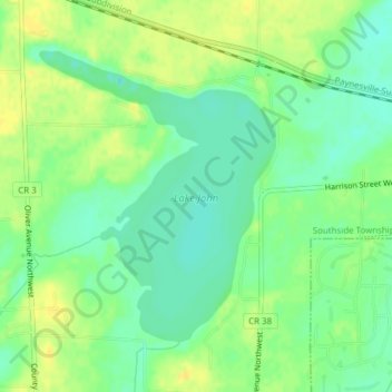
Name: Topografische Karte Lake John, Höhe, Relief.

Ort: Lake John, 80th Street Northwest, Wright County, Minnesota, 55302, United States of America (45.24976 -94.17865 45.26982 -94.15538)

Durchschnittliche Höhe: 326 m

Minimale Höhe: 315 m

Maximale Höhe: 337 m

Andere topografische Karten

Klicken Sie auf eine Karte, um ihre Topografie, ihre Höhe und ihr Relief anzuzeigen.

Middle River

United States of America > Minnesota > Middle River

Durchschnittliche Höhe: 350 m

Kensington

United States of America > Minnesota > Kensington

Durchschnittliche Höhe: 398 m

Angora

United States of America > Minnesota > Angora

Durchschnittliche Höhe: 418 m

Deer Park

United States of America > Minnesota > Lakeville > Deer Park

Durchschnittliche Höhe: 306 m

Florence

United States of America > Minnesota > Florence > Florence

Durchschnittliche Höhe: 520 m

French

United States of America > Minnesota > French

Durchschnittliche Höhe: 342 m

Crow Wing

United States of America > Minnesota

Durchschnittliche Höhe: 392 m

Harding

United States of America > Minnesota > Harding

Durchschnittliche Höhe: 384 m

Edinborough

United States of America > Minnesota > Edina

Durchschnittliche Höhe: 261 m

Villard

United States of America > Minnesota > Villard

Durchschnittliche Höhe: 416 m