
Topografische Karte Montvale
Interaktive Karte
Klicken Sie auf die Karte, um die Höhe anzuzeigen.
Über diese Karte
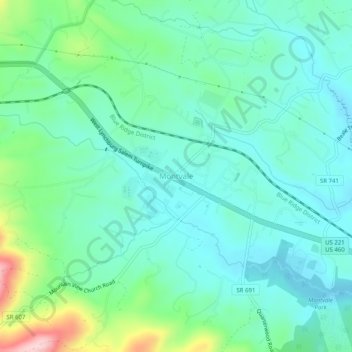
Name: Topografische Karte Montvale, Höhe, Relief.
Ort: Montvale, Bedford County, Virginia, 24122, United States (37.36458 -79.75115 37.40458 -79.71115)
Durchschnittliche Höhe: 327 m
Minimale Höhe: 270 m
Maximale Höhe: 519 m
Andere topografische Karten
Klicken Sie auf eine Karte, um ihre Topografie, ihre Höhe und ihr Relief anzuzeigen.
Smith Mountain Lake State Park
United States > Virginia > Bedford County
Smith Mountain Lake State Park, 1235, State Park Road, Bedford County, Virginia, 24104, United States
Durchschnittliche Höhe: 259 m
Elk Creek
United States > Virginia > Bedford County
Elk Creek, Bedford County, Virginia, 24570, United States
Durchschnittliche Höhe: 220 m
Coleman Falls
United States > Virginia > Bedford County
Coleman Falls, Bedford County, Virginia, 24536, United States
Durchschnittliche Höhe: 244 m
Big Island
United States > Virginia > Bedford County
Big Island, Bedford County, Virginia, 24526, United States
Durchschnittliche Höhe: 238 m
Villamont
United States > Virginia > Bedford County
Villamont, Bedford County, Virginia, 24064, United States
Durchschnittliche Höhe: 485 m
Perrowville
United States > Virginia > Bedford County
Perrowville, Bedford County, Virginia, United States
Durchschnittliche Höhe: 299 m
Stewartsville
United States > Virginia > Bedford County
Stewartsville, Bedford County, Virginia, United States
Durchschnittliche Höhe: 319 m
Sedalia
United States > Virginia > Bedford County
Sedalia, Bedford County, Virginia, 24526, United States
Durchschnittliche Höhe: 337 m
Huddleston
United States > Virginia > Bedford County
Huddleston, Bedford County, Virginia, United States
Durchschnittliche Höhe: 226 m
Hardy
United States > Virginia > Bedford County
Hardy, Bedford County, Virginia, United States
Durchschnittliche Höhe: 289 m
Tyler Knob
United States > Virginia > Bedford County
Tyler Knob, Bedford County, Virginia, United States
Durchschnittliche Höhe: 429 m
Moneta
United States > Virginia > Bedford County
Moneta, Bedford County, Virginia, 24121, United States
Durchschnittliche Höhe: 273 m
Thaxton
United States > Virginia > Bedford County
Thaxton, Bedford County, Virginia, United States
Durchschnittliche Höhe: 304 m
Goodview
United States > Virginia > Bedford County
Goodview, Bedford County, Virginia, 24095, United States
Durchschnittliche Höhe: 289 m
Goode
United States > Virginia > Bedford County
Goode, Bedford County, Virginia, 24556, United States
Durchschnittliche Höhe: 253 m
Peaks of Otter Dam
United States > Virginia > Bedford County
Peaks of Otter Dam, Bedford County, Virginia, United States
Durchschnittliche Höhe: 838 m
Bedford
United States > Virginia > Bedford County
Bedford, Bedford County, Virginia, 24523, United States
Durchschnittliche Höhe: 285 m
Forest
United States > Virginia > Bedford County
Forest, Bedford County, Virginia, 24551, United States
Durchschnittliche Höhe: 256 m
Lowry
United States > Virginia > Bedford County
Lowry, Bedford County, Virginia, 24570, United States
Durchschnittliche Höhe: 246 m