
Topografische Karte Pino Suárez
Interaktive Karte
Klicken Sie auf die Karte, um die Höhe anzuzeigen.
Über diese Karte
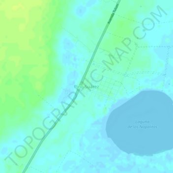
Name: Topografische Karte Pino Suárez, Höhe, Relief.
Ort: Pino Suárez, Felipe Carrillo Puerto, Quintana Roo, México (20.09040 -87.61121 20.13040 -87.57121)
Durchschnittliche Höhe: 4 m
Minimale Höhe: -4 m
Maximale Höhe: 14 m
Andere topografische Karten
Klicken Sie auf eine Karte, um ihre Topografie, ihre Höhe und ihr Relief anzuzeigen.
Nueva Israel
México > Quintana Roo > Felipe Carrillo Puerto
Nueva Israel, Felipe Carrillo Puerto, Quintana Roo, México
Durchschnittliche Höhe: 18 m
Chun On
México > Quintana Roo > Felipe Carrillo Puerto > Chun On
Chun On, Felipe Carrillo Puerto, Quintana Roo, México
Durchschnittliche Höhe: 14 m
Santa María Poniente
México > Quintana Roo > Felipe Carrillo Puerto > Santa María Poniente
Santa María Poniente, Felipe Carrillo Puerto, Quintana Roo, México
Durchschnittliche Höhe: 18 m
Presidente Juárez
México > Quintana Roo > Felipe Carrillo Puerto > Presidente Juárez
Presidente Juárez, Felipe Carrillo Puerto, Quintana Roo, México
Durchschnittliche Höhe: 23 m