
Topografische Karte Kumbakonam
Interaktive Karte
Klicken Sie auf die Karte, um die Höhe anzuzeigen.
Kumbakonam
Kumbakonam is located at 10°58′N 79°25′E / 10.97°N 79.42°E / 10.97; 79.42. It is situated 273 km (170 mi) south of Chennai, 96 km (60 mi) east of Tiruchirappalli, and about 40 km (25 mi) north-east of Thanjavur. It lies in the region called the "Old delta" which comprises the north-western taluks of Thanjavur district that have been naturally irrigated by the waters of the Cauvery and its tributaries for centuries in contrast to the "New Delta" comprising the southern taluks that were brought under irrigation by the construction of the Grand Anicut canal and the Vadavar canal in 1934. It has an average elevation of 26 metres (85 ft). The town is bounded by two rivers, the Cauvery River on the north and Arasalar River on the south.
Über diese Karte
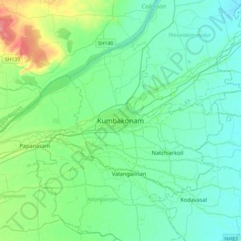
Name: Topografische Karte Kumbakonam, Höhe, Relief.
Ort: Kumbakonam, Thanjavur District, Tamil Nadu, 612001, India (10.80041 79.22209 11.12041 79.54209)
Durchschnittliche Höhe: 27 m
Minimale Höhe: 13 m
Maximale Höhe: 80 m