
Topografische Karte Ringgold
Interaktive Karte
Klicken Sie auf die Karte, um die Höhe anzuzeigen.
Über diese Karte
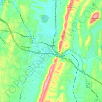
Name: Topografische Karte Ringgold, Höhe, Relief.
Ort: Ringgold, Catoosa County, Georgia, United States (34.88789 -85.19659 34.93480 -85.08769)
Durchschnittliche Höhe: 268 m
Minimale Höhe: 209 m
Maximale Höhe: 407 m
Ringgold is situated in the Valley and Ridge geologic province of the Appalachian Mountains, characterized by long north-northeasterly trending ridges separated by valleys. The topography was formed by the erosion of alternating layers of hard and soft sedimentary rock that were folded and faulted during the building of the Appalachians. Taylor Ridge runs through Ringgold; a gap in the ridge is located just east of the city center, with the part of the ridge running to the south called Taylors Ridge and to the north called White Oak Mountain. South Chickamauga Creek, a tributary of the Tennessee River, runs through Ringgold.
Andere topografische Karten
Klicken Sie auf eine Karte, um ihre Topografie, ihre Höhe und ihr Relief anzuzeigen.
Boynton
United States > Georgia > Catoosa County
Boynton, Catoosa County, Georgia, 30736, United States
Durchschnittliche Höhe: 239 m
Lakeview
United States > Georgia > Catoosa County > Fort Oglethorpe
Lakeview, Fort Oglethorpe, Catoosa County, Georgia, United States
Durchschnittliche Höhe: 237 m
Indian Springs
United States > Georgia > Catoosa County
Indian Springs, Catoosa County, Georgia, United States
Durchschnittliche Höhe: 236 m
Blue Spring
United States > Georgia > Catoosa County
Blue Spring, Catoosa County, Georgia, United States, Blue Spring Lake
Durchschnittliche Höhe: 236 m
Cloud Springs
United States > Georgia > Catoosa County > Fort Oglethorpe
Cloud Springs, Fort Oglethorpe, Catoosa County, Georgia, 30742, United States
Durchschnittliche Höhe: 237 m
Fort Oglethorpe
United States > Georgia > Catoosa County
Fort Oglethorpe, Catoosa County, Georgia, 30742, United States
Durchschnittliche Höhe: 236 m