
Topografische Karte Cayey
Interaktive Karte
Klicken Sie auf die Karte, um die Höhe anzuzeigen.
Über diese Karte
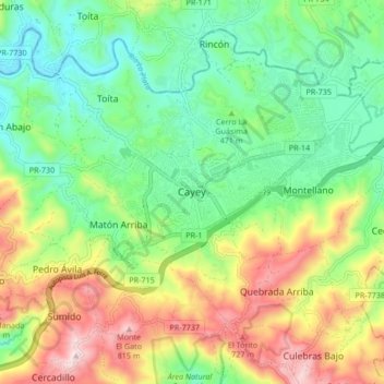
Name: Topografische Karte Cayey, Höhe, Relief.
Ort: Cayey, 00736, United States (18.07269 -66.20628 18.15269 -66.12628)
Durchschnittliche Höhe: 489 m
Minimale Höhe: 284 m
Maximale Höhe: 840 m
Cayey's climate is humid, rainy and mild compared to lower-elevation areas of the island, the area of the town is nearly 1,500 feet (460 m) high, so the climate is subtropical high. In summer average high Temperatures are around 82 °F to 88 °F and 70 °F to 78 °F in winter, and low around 68 °F to 72 °F in summer and 57 °F to 63 °F in winter. The record maximum temperature is 94 °F (34 °C) and minimum 45 °F (7 °C). The average annual rainfall is 100 inches (2,540 mm) and maximum rainfall record in 24 hours is 20.87 inches (530 mm) of rain.