
Spenden
Rüste dich für dein nächstes Abenteuer:
Als Amazon-Partner verdient diese Website an qualifizierten Käufen, ohne zusätzliche Kosten für Sie.
Topografische Karte Hudson River
Klicken Sie auf die Karte, um die Höhe anzuzeigen.
Spenden
Rüste dich für dein nächstes Abenteuer:
Als Amazon-Partner verdient diese Website an qualifizierten Käufen, ohne zusätzliche Kosten für Sie.
Hudson River
The Hudson then flows south, taking in Beaver Brook and the outlet of Lake Harris. After its confluence with the Indian River, the Hudson forms the boundary between Essex and Hamilton counties. In the hamlet of North River, the Hudson flows entirely in Warren County and takes in the Schroon River. Further south, the river forms the boundary between Warren and Saratoga Counties. The river then takes in the Sacandaga River from the Great Sacandaga Lake. Shortly thereafter, the river leaves the Adirondack Park, flows under Interstate 87, and through Glens Falls, just south of Lake George although receiving no streamflow from the lake. It next goes through Hudson Falls. At this point the river forms the boundary between Washington and Saratoga Counties. Here the river has an elevation of 200 feet (61 m). Just south in Fort Edward, the river reaches its confluence with the Champlain Canal, which historically provided boat traffic between New York City and Montreal and the rest of Eastern Canada via the Hudson, Lake Champlain and the Saint Lawrence Seaway. Further south the Hudson takes in water from the Batten Kill River and Fish Creek near Schuylerville. The river then forms the boundary between Saratoga and Rensselaer counties. The river then enters the heart of the Capital District. It takes in water from the Hoosic River, which extends into Massachusetts. Shortly thereafter the river has its confluence with the Mohawk River, the largest tributary of the Hudson River, in Waterford. The river then reaches the Federal Dam in Troy, marking an impoundment of the river. At an elevation of 2 feet (0.61 m), the bottom of the dam marks the beginning of the tidal influence in the Hudson as well as the beginning of the lower Hudson River.
Spenden
Rüste dich für dein nächstes Abenteuer:
Als Amazon-Partner verdient diese Website an qualifizierten Käufen, ohne zusätzliche Kosten für Sie.
Über diese Karte
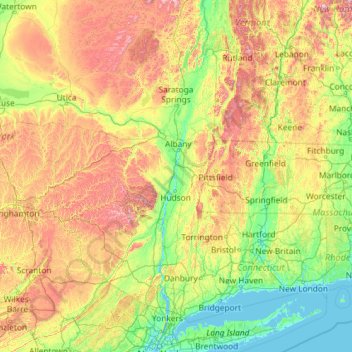
Name: Topografische Karte Hudson River, Höhe, Relief.
Ort: Hudson River, New York, United States (40.65258 -74.19885 44.09099 -73.57319)
Durchschnittliche Höhe: 297 m
Minimale Höhe: -2 m
Maximale Höhe: 1.384 m
Spenden
Rüste dich für dein nächstes Abenteuer:
Als Amazon-Partner verdient diese Website an qualifizierten Käufen, ohne zusätzliche Kosten für Sie.
Andere topografische Karten
Klicken Sie auf eine Karte, um ihre Topografie, ihre Höhe und ihr Relief anzuzeigen.
Central Park
United States > New York > New York County > New York
In June 1856, Fernando Wood appointed a "consulting board" of seven people, headed by author Washington Irving, to inspire public confidence in the proposed development. Wood hired military engineer Egbert Ludovicus Viele as the park's chief engineer, tasking him with a topographical survey of the site. The…
Durchschnittliche Höhe: 26 m
Tug Hill
United States > New York > Oswego County
The core Tug Hill region encompasses 150,000 acres (610 km2) of unbroken, generally second-growth, northern hardwood forest, and is drained by a vast network of streams. Important rivers and streams whose headwaters are located within the Tug Hill region include the Mohawk River, Deer River, Salmon River, Mad…
Durchschnittliche Höhe: 109 m
Central Park
United States > New York > New York County > New York
In June 1856, Fernando Wood appointed a "consulting board" of seven people, headed by author Washington Irving, to inspire public confidence in the proposed development. Wood hired military engineer Egbert Ludovicus Viele as the park's chief engineer, tasking him with a topographical survey of the site. The…
Durchschnittliche Höhe: 26 m
Spenden
Rüste dich für dein nächstes Abenteuer:
Als Amazon-Partner verdient diese Website an qualifizierten Käufen, ohne zusätzliche Kosten für Sie.
Big Bad Luck Pond
United States > New York > Hamilton County > Town of Indian Lake
Durchschnittliche Höhe: 539 m
North Fair Haven
United States > New York > Cayuga County > Town of Sterling
Durchschnittliche Höhe: 82 m
Ellicottville
United States > New York > Cattaraugus County > Village of Ellicottville
Durchschnittliche Höhe: 573 m
Spenden
Rüste dich für dein nächstes Abenteuer:
Als Amazon-Partner verdient diese Website an qualifizierten Käufen, ohne zusätzliche Kosten für Sie.
Kane's Falls
United States > New York > Washington County > Town of Fort Ann
Durchschnittliche Höhe: 59 m
Spenden
Rüste dich für dein nächstes Abenteuer:
Als Amazon-Partner verdient diese Website an qualifizierten Käufen, ohne zusätzliche Kosten für Sie.
Tusten Mountain Lake
United States > New York > Sullivan County > Town of Tusten
Durchschnittliche Höhe: 346 m
Mount Tremper
United States > New York > Ulster County > Town of Shandaken
Durchschnittliche Höhe: 343 m
Spenden
Rüste dich für dein nächstes Abenteuer:
Als Amazon-Partner verdient diese Website an qualifizierten Käufen, ohne zusätzliche Kosten für Sie.
Mount Marcy
United States > New York > Essex County > Town of Keene
Mount Marcy is the highest point in the Adirondack Mountains and the U.S. state of New York, with an elevation of 5,343.1 feet (1,628.6 m). It is located in the town of Keene in Essex County. The mountain is in the heart of the High Peaks Wilderness Area in Adirondack Park. Like the surrounding Adirondack…
Durchschnittliche Höhe: 1.289 m
Spenden
Rüste dich für dein nächstes Abenteuer:
Als Amazon-Partner verdient diese Website an qualifizierten Käufen, ohne zusätzliche Kosten für Sie.
Hartfield
United States > New York > Chautauqua County > Town of Chautauqua
Durchschnittliche Höhe: 428 m
Chenango Lake
United States > New York > Chenango County > Town of New Berlin
Durchschnittliche Höhe: 513 m
Spenden
Rüste dich für dein nächstes Abenteuer:
Als Amazon-Partner verdient diese Website an qualifizierten Käufen, ohne zusätzliche Kosten für Sie.
Lake Lincolndale
United States > New York > Westchester County > Town of Somers > Shenorock
Durchschnittliche Höhe: 162 m
Spenden
Rüste dich für dein nächstes Abenteuer:
Als Amazon-Partner verdient diese Website an qualifizierten Käufen, ohne zusätzliche Kosten für Sie.
Cedar Knolls
United States > New York > Westchester County > City of Yonkers
Durchschnittliche Höhe: 57 m
Spenden
Rüste dich für dein nächstes Abenteuer:
Als Amazon-Partner verdient diese Website an qualifizierten Käufen, ohne zusätzliche Kosten für Sie.
New Britain
United States > New York > Columbia County > Town of New Lebanon
Durchschnittliche Höhe: 311 m
Spenden
Rüste dich für dein nächstes Abenteuer:
Als Amazon-Partner verdient diese Website an qualifizierten Käufen, ohne zusätzliche Kosten für Sie.
Spenden
Rüste dich für dein nächstes Abenteuer:
Als Amazon-Partner verdient diese Website an qualifizierten Käufen, ohne zusätzliche Kosten für Sie.
Mohegan Lake
United States > New York > Westchester County > Lake Mohegan
Durchschnittliche Höhe: 127 m
Spenden
Rüste dich für dein nächstes Abenteuer:
Als Amazon-Partner verdient diese Website an qualifizierten Käufen, ohne zusätzliche Kosten für Sie.
East Poestenkill
United States > New York > Rensselaer County > Town of Poestenkill
Durchschnittliche Höhe: 376 m
Spenden
Rüste dich für dein nächstes Abenteuer:
Als Amazon-Partner verdient diese Website an qualifizierten Käufen, ohne zusätzliche Kosten für Sie.
Beaver Dam Lake
United States > New York > Orange County > Town of New Windsor
Durchschnittliche Höhe: 118 m
Spenden
Rüste dich für dein nächstes Abenteuer:
Als Amazon-Partner verdient diese Website an qualifizierten Käufen, ohne zusätzliche Kosten für Sie.
Cicero Center
United States > New York > Onondaga County > Town of Cicero
Durchschnittliche Höhe: 120 m
Handsome Pond
United States > New York > Hamilton County > Town of Long Lake
Durchschnittliche Höhe: 587 m
Spenden
Rüste dich für dein nächstes Abenteuer:
Als Amazon-Partner verdient diese Website an qualifizierten Käufen, ohne zusätzliche Kosten für Sie.
Hawthorne
United States > New York > Westchester County > Town of Mount Pleasant
Durchschnittliche Höhe: 119 m
Lower South Bay
United States > New York > Onondaga County > Town of Cicero
Durchschnittliche Höhe: 117 m
Green Acres
United States > New York > Nassau County > South Valley Stream
Durchschnittliche Höhe: 6 m
Spenden
Rüste dich für dein nächstes Abenteuer:
Als Amazon-Partner verdient diese Website an qualifizierten Käufen, ohne zusätzliche Kosten für Sie.
East Hauppauge
United States > New York > Suffolk County > Town of Smithtown
Durchschnittliche Höhe: 28 m
Saint Andrew
United States > New York > Orange County > Town of Montgomery
Durchschnittliche Höhe: 138 m
Spenden
Rüste dich für dein nächstes Abenteuer:
Als Amazon-Partner verdient diese Website an qualifizierten Käufen, ohne zusätzliche Kosten für Sie.
Reynolds
United States > New York > Rensselaer County > Town of Schaghticoke
Durchschnittliche Höhe: 44 m
Roberto Clemente State Park
United States > New York > Bronx County > New York
Durchschnittliche Höhe: 32 m
Spenden
Rüste dich für dein nächstes Abenteuer:
Als Amazon-Partner verdient diese Website an qualifizierten Käufen, ohne zusätzliche Kosten für Sie.
Upper Lansingburg Reservoir Dam
United States > New York > Rensselaer County > City of Troy
Durchschnittliche Höhe: 92 m
Mott Point
United States > New York > Nassau County > Village of Sands Point
Durchschnittliche Höhe: 11 m
Spenden
Rüste dich für dein nächstes Abenteuer:
Als Amazon-Partner verdient diese Website an qualifizierten Käufen, ohne zusätzliche Kosten für Sie.
Cedar Knolls
United States > New York > Westchester County > City of Yonkers
Durchschnittliche Höhe: 57 m
Spenden
Rüste dich für dein nächstes Abenteuer:
Als Amazon-Partner verdient diese Website an qualifizierten Käufen, ohne zusätzliche Kosten für Sie.
Catskills Visitor Center
United States > New York > Ulster County > Town of Shandaken > Beechford
Durchschnittliche Höhe: 301 m
Spenden
Rüste dich für dein nächstes Abenteuer:
Als Amazon-Partner verdient diese Website an qualifizierten Käufen, ohne zusätzliche Kosten für Sie.
Spenden
Rüste dich für dein nächstes Abenteuer:
Als Amazon-Partner verdient diese Website an qualifizierten Käufen, ohne zusätzliche Kosten für Sie.
Benjamin's Memorial Beach
United States > New York > Suffolk County > Bay Shore
Durchschnittliche Höhe: 2 m
Fisherman's Landing
United States > New York > Erie County > Town of Grand Island > Grandyle Village
Durchschnittliche Höhe: 179 m
Barberville
United States > New York > Rensselaer County > Town of Poestenkill
Durchschnittliche Höhe: 269 m
Chestnut Ridge Park
United States > New York > Erie County > Town of Orchard Park
Durchschnittliche Höhe: 314 m
Spenden
Rüste dich für dein nächstes Abenteuer:
Als Amazon-Partner verdient diese Website an qualifizierten Käufen, ohne zusätzliche Kosten für Sie.
West Canada Creek
United States > New York > Oneida County > Town of Trenton
Durchschnittliche Höhe: 242 m
Spenden
Rüste dich für dein nächstes Abenteuer:
Als Amazon-Partner verdient diese Website an qualifizierten Käufen, ohne zusätzliche Kosten für Sie.
Trumbull Corners
United States > New York > Tompkins County > Town of Newfield
Durchschnittliche Höhe: 443 m
Ellicottville
United States > New York > Cattaraugus County > Village of Ellicottville
Durchschnittliche Höhe: 573 m
Spenden
Rüste dich für dein nächstes Abenteuer:
Als Amazon-Partner verdient diese Website an qualifizierten Käufen, ohne zusätzliche Kosten für Sie.
Benjamin's Memorial Beach
United States > New York > Suffolk County > Bay Shore
Durchschnittliche Höhe: 2 m
Vails Gate Junction
United States > New York > Orange County > Town of New Windsor > Vails Gate
Durchschnittliche Höhe: 92 m
Spenden
Rüste dich für dein nächstes Abenteuer:
Als Amazon-Partner verdient diese Website an qualifizierten Käufen, ohne zusätzliche Kosten für Sie.