
Topografische Karte Hudson River
Interaktive Karte
Klicken Sie auf die Karte, um die Höhe anzuzeigen.
Hudson River
The Hudson then flows south, taking in Beaver Brook and the outlet of Lake Harris. After its confluence with the Indian River, the Hudson forms the boundary between Essex and Hamilton counties. In the hamlet of North River, the Hudson flows entirely in Warren County and takes in the Schroon River. Further south, the river forms the boundary between Warren and Saratoga Counties. The river then takes in the Sacandaga River from the Great Sacandaga Lake. Shortly thereafter, the river leaves the Adirondack Park, flows under Interstate 87, and through Glens Falls, just south of Lake George although receiving no streamflow from the lake. It next goes through Hudson Falls. At this point the river forms the boundary between Washington and Saratoga Counties. Here the river has an elevation of 200 feet (61 m). Just south in Fort Edward, the river reaches its confluence with the Champlain Canal, which historically provided boat traffic between New York City and Montreal and the rest of Eastern Canada via the Hudson, Lake Champlain and the Saint Lawrence Seaway. Further south the Hudson takes in water from the Batten Kill River and Fish Creek near Schuylerville. The river then forms the boundary between Saratoga and Rensselaer counties. The river then enters the heart of the Capital District. It takes in water from the Hoosic River, which extends into Massachusetts. Shortly thereafter the river has its confluence with the Mohawk River, the largest tributary of the Hudson River, in Waterford. The river then reaches the Federal Dam in Troy, marking an impoundment of the river. At an elevation of 2 feet (0.61 m), the bottom of the dam marks the beginning of the tidal influence in the Hudson as well as the beginning of the lower Hudson River.
Über diese Karte
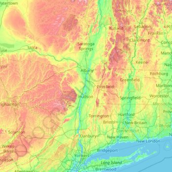
Name: Topografische Karte Hudson River, Höhe, Relief.
Ort: Hudson River, New York, United States (40.65258 -74.19885 44.09099 -73.57319)
Durchschnittliche Höhe: 297 m
Minimale Höhe: -2 m
Maximale Höhe: 1.384 m
Andere topografische Karten
Klicken Sie auf eine Karte, um ihre Topografie, ihre Höhe und ihr Relief anzuzeigen.
Central Park
United States > New York > New York County > New York
In June 1856, Fernando Wood appointed a "consulting board" of seven people, headed by author Washington Irving, to inspire public confidence in the proposed development. Wood hired military engineer Egbert Ludovicus Viele as the park's chief engineer, tasking him with a topographical survey of the site. The…
Durchschnittliche Höhe: 26 m
East Lancaster
United States > New York > Erie County > Town of Lancaster
Durchschnittliche Höhe: 216 m
Niagara Escarpment
United States > New York > Niagara County > City of Lockport
Durchschnittliche Höhe: 149 m
South Setauket
United States > New York > Suffolk County > Town of Brookhaven
Durchschnittliche Höhe: 44 m
Central Park
United States > New York > New York County > New York
In June 1856, Fernando Wood appointed a "consulting board" of seven people, headed by author Washington Irving, to inspire public confidence in the proposed development. Wood hired military engineer Egbert Ludovicus Viele as the park's chief engineer, tasking him with a topographical survey of the site. The…
Durchschnittliche Höhe: 26 m
Holiday Valley
United States > New York > Cattaraugus County > Ellicottville
Durchschnittliche Höhe: 545 m
Northville
United States > New York > Fulton County > Village of Northville
Durchschnittliche Höhe: 280 m
Platte Clove
United States > New York > Greene County > Town of Hunter > Platte Clove Bruderhof
Durchschnittliche Höhe: 575 m
Fort Edward Feeder Canal
United States > New York > Washington County > Village of Fort Edward
Durchschnittliche Höhe: 57 m
West Somerset
United States > New York > Niagara County > Town of Somerset
Durchschnittliche Höhe: 100 m
Kitchawan
United States > New York > Westchester County > Town of Yorktown
Durchschnittliche Höhe: 111 m
Coney Island
United States > New York > Saint Lawrence County > Town of Pierrepont
Durchschnittliche Höhe: 174 m
Buckhout Corners
United States > New York > Westchester County > Village of Briarcliff Manor
Durchschnittliche Höhe: 112 m
Mohegan Heights
United States > New York > Westchester County > City of Yonkers
Durchschnittliche Höhe: 58 m
Cooper Lake
United States > New York > Ulster County > Town of Woodstock > Lake Hill
Durchschnittliche Höhe: 367 m
Kaaterskill High Peak
United States > New York > Greene County > Town of Hunter
Durchschnittliche Höhe: 850 m
Harbor Hills Park
United States > New York > Nassau County > Village of Great Neck Estates
Durchschnittliche Höhe: 10 m
Snyders Lake
United States > New York > Rensselaer County > Snyders Corner
Durchschnittliche Höhe: 164 m
Woodcrest Bruderhof
United States > New York > Ulster County > Town of Esopus
Durchschnittliche Höhe: 84 m
Cowdens Corner
United States > New York > Chautauqua County > Town of Arkwright
Durchschnittliche Höhe: 389 m
Little Red Lighthouse
United States > New York > New York County > New York
Durchschnittliche Höhe: 27 m
Hunts Corner
United States > New York > Sullivan County > Town of Tusten
Durchschnittliche Höhe: 296 m
Constantia Center
United States > New York > Oswego County > Town of Constantia
Durchschnittliche Höhe: 169 m
Dunham Hollow
United States > New York > Rensselaer County > Town of Nassau
Durchschnittliche Höhe: 371 m
South New Berlin
United States > New York > Chenango County > Town of New Berlin
Durchschnittliche Höhe: 380 m
East Cutchogue
United States > New York > Suffolk County > Town of Southold
Durchschnittliche Höhe: 9 m
Woodcock Mountain
United States > New York > Saratoga County > Town of Hadley
Durchschnittliche Höhe: 271 m
Ellenburg Mountain
United States > New York > Clinton County > Town of Ellenburg
Durchschnittliche Höhe: 682 m
Grand Gorge
United States > New York > Delaware County > Town of Roxbury
Durchschnittliche Höhe: 508 m
Niagara Escarpment
United States > New York > Niagara County > City of Lockport
Durchschnittliche Höhe: 149 m
Kitchawan
United States > New York > Westchester County > Town of Yorktown
Durchschnittliche Höhe: 111 m
Lake Katonah
United States > New York > Westchester County > Town of Lewisboro
Durchschnittliche Höhe: 127 m
Mount Marcy
United States > New York > Essex County > Town of Keene
Mount Marcy is the highest point in the Adirondack Mountains and the U.S. state of New York, with an elevation of 5,343.1 feet (1,628.6 m). It is located in the town of Keene in Essex County. The mountain is in the heart of the High Peaks Wilderness Area in Adirondack Park. Like the surrounding Adirondack…
Durchschnittliche Höhe: 1.289 m
Fruit Street Sitting Area
United States > New York > Kings County > New York
Durchschnittliche Höhe: 10 m
Jacobs Hill
United States > New York > Suffolk County > Town of Riverhead
Durchschnittliche Höhe: 11 m
Wurtemburg
United States > New York > Dutchess County > Town of Rhinebeck
Durchschnittliche Höhe: 124 m
West Coxsackie
United States > New York > Greene County > Village of Coxsackie
Durchschnittliche Höhe: 33 m
Jackson Corners
United States > New York > Dutchess County > Town of Milan
Durchschnittliche Höhe: 161 m
Bald Hill
United States > New York > Suffolk County > Town of Southampton
Durchschnittliche Höhe: 47 m
Fruit Street Sitting Area
United States > New York > Kings County > New York
Durchschnittliche Höhe: 10 m
Ontario Pond
United States > New York > Niagara County > City of North Tonawanda
Durchschnittliche Höhe: 177 m
West Genesee Terrace
United States > New York > Onondaga County > Fairmount > Town of Camillus
Durchschnittliche Höhe: 167 m