
Topografische Karte Radcliff
Interaktive Karte
Klicken Sie auf die Karte, um die Höhe anzuzeigen.
Über diese Karte
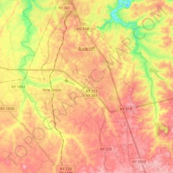
Name: Topografische Karte Radcliff, Höhe, Relief.
Ort: Radcliff, Hardin County, Kentucky, 40160, United States (37.74857 -85.98154 37.87633 -85.88425)
Durchschnittliche Höhe: 223 m
Minimale Höhe: 145 m
Maximale Höhe: 272 m
Andere topografische Karten
Klicken Sie auf eine Karte, um ihre Topografie, ihre Höhe und ihr Relief anzuzeigen.
Limp
United States > Kentucky > Hardin County
Limp, Hardin County, Kentucky, United States
Durchschnittliche Höhe: 211 m
Elizabethtown
United States > Kentucky > Hardin County
Elizabethtown, Hardin County, Kentucky, 42701, United States
Durchschnittliche Höhe: 241 m
West Point
United States > Kentucky > Hardin County
West Point, Hardin County, Kentucky, United States
Durchschnittliche Höhe: 163 m
Hardin County
United States > Kentucky > Hardin County
Hardin County, Kentucky, United States
Durchschnittliche Höhe: 212 m
Cecil Hill
United States > Kentucky > Hardin County
Cecil Hill, Hardin County, Kentucky, 42724, United States
Durchschnittliche Höhe: 230 m
Kraft
United States > Kentucky > Hardin County
Kraft, Hardin County, Kentucky, 40162, United States
Durchschnittliche Höhe: 247 m
Vine Grove
United States > Kentucky > Hardin County
Vine Grove, Hardin County, Kentucky, United States
Durchschnittliche Höhe: 218 m
West Point
United States > Kentucky > Hardin County > West Point
West Point, Hardin County, Kentucky, 40177, United States
Durchschnittliche Höhe: 169 m