
Topografische Karte Puerto Vallarta
Interaktive Karte
Klicken Sie auf die Karte, um die Höhe anzuzeigen.
Puerto Vallarta
Fourth: In 1968 the Puerto Vallarta municipality was elevated to City status. The elevation in status reflected interest by Mexican federal and state governments in developing the Puerto Vallarta as an international resort destination. Puerto Vallarta has since also attracted a lively immigrant community from the U.S., Canada and Europe.
Über diese Karte
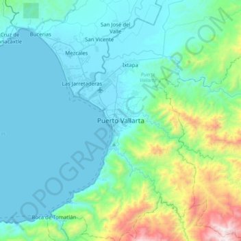
Name: Topografische Karte Puerto Vallarta, Höhe, Relief.
Durchschnittliche Höhe: 306 m
Minimale Höhe: 0 m
Maximale Höhe: 1.881 m