
Topografische Karte Apple Valley
Interaktive Karte
Klicken Sie auf die Karte, um die Höhe anzuzeigen.
Apple Valley
According to the United States Census Bureau, the city has a total area of 17.57 square miles (45.51 km2), of which 16.86 square miles (43.67 km2) is land and 0.71 square miles (1.84 km2) is water. The city's geography is rolling, with elevation from the lowest to the highest points in the city varying by one hundred feet (thirty metres) or more. The downtown area and its adjacent residential district (which formed the original core of the city when it was incorporated) are in a shallow valley.
Über diese Karte
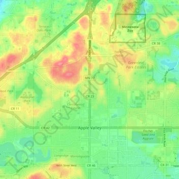
Name: Topografische Karte Apple Valley, Höhe, Relief.
Ort: Apple Valley, Dakota County, Minnesota, 55124, United States (44.71734 -93.24835 44.77589 -93.15134)
Durchschnittliche Höhe: 301 m
Minimale Höhe: 270 m
Maximale Höhe: 343 m
Andere topografische Karten
Klicken Sie auf eine Karte, um ihre Topografie, ihre Höhe und ihr Relief anzuzeigen.
Burnsville
United States > Minnesota > Dakota County > Burnsville > Burnsville
Durchschnittliche Höhe: 275 m
Farmington
United States > Minnesota > Dakota County > Farmington > Farmington
Durchschnittliche Höhe: 280 m