
Topografische Karte Caraque
Interaktive Karte
Klicken Sie auf die Karte, um die Höhe anzuzeigen.
Über diese Karte
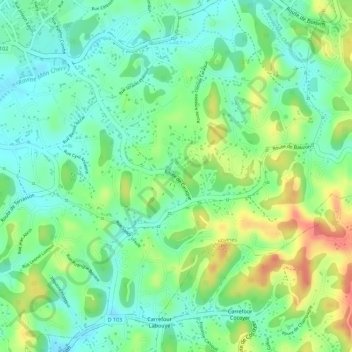
Name: Topografische Karte Caraque, Höhe, Relief.
Durchschnittliche Höhe: 40 m
Minimale Höhe: 11 m
Maximale Höhe: 86 m
Andere topografische Karten
Klicken Sie auf eine Karte, um ihre Topografie, ihre Höhe und ihr Relief anzuzeigen.
Dothémare
France > Guadeloupe > Les Abymes
Dothémare, Les Abymes, Pointe-à-Pitre, Guadeloupe, 97139, France
Durchschnittliche Höhe: 18 m
Boisvin
France > Guadeloupe > Les Abymes
Boisvin, Les Abymes, Pointe-à-Pitre, Guadeloupe, 97139, France
Durchschnittliche Höhe: 40 m
Chazeau
France > Guadeloupe > Les Abymes
Chazeau, Les Abymes, Pointe-à-Pitre, Guadeloupe, 97111, France
Durchschnittliche Höhe: 34 m