
Topografische Karte Ku-ring-gai Chase National Park
Interaktive Karte
Klicken Sie auf die Karte, um die Höhe anzuzeigen.
Ku-ring-gai Chase National Park
Ku-ring-gai Chase is part of the Hornsby Plateau, a massive block of sandstone tilting upwards to the north. The park comprises a plateau with an elevation of generally 150–200 m above sea level. Between 250 and 200 million years ago, sand silt and mud was deposited by rivers across flood plains. These formed the shales, flagstones and sandstones of the Narrabeen Group that outcrop along the foreshores and ridges. Higher areas of the park are underlain with pink, white and orange layers of Hawkesbury Sandstone that contain small beds of shale. Wianamatta Group shale is present in the higher points of the park. The park's terraced landscape is due to the horizontal arrangement of these sediment layers.
Über diese Karte
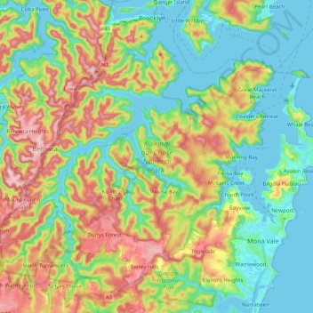
Name: Topografische Karte Ku-ring-gai Chase National Park, Höhe, Relief.
Durchschnittliche Höhe: 83 m
Minimale Höhe: -4 m
Maximale Höhe: 230 m
Andere topografische Karten
Klicken Sie auf eine Karte, um ihre Topografie, ihre Höhe und ihr Relief anzuzeigen.
George Kendall Park Dog Off-Leash Area
Australia > New South Wales > Sydney
Durchschnittliche Höhe: 15 m