
Topografische Karte Oxford
Interaktive Karte
Klicken Sie auf die Karte, um die Höhe anzuzeigen.
Oxford
The city is located in the North Central Hills region of Mississippi. The region is known for its heavily forested hills made up of red clay. The area is higher and greater in relief than areas to the west (such as the Mississippi Delta or loess bluffs along the Delta), but lower in elevation than areas in northeast Mississippi. The changes in elevation can be noticed when traveling on the Highway 6 bypass, since the east-west highway tends to transect many of the north-south ridges. Downtown Oxford sits on one of these ridges and the University of Mississippi sits on another one, while the main commercial corridors on either side of the city sit in valleys.
Über diese Karte
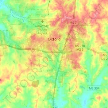
Name: Topografische Karte Oxford, Höhe, Relief.
Ort: Oxford, Lafayette County, Mississippi, United States (34.31046 -89.59668 34.39417 -89.47522)
Durchschnittliche Höhe: 132 m
Minimale Höhe: 92 m
Maximale Höhe: 178 m
Andere topografische Karten
Klicken Sie auf eine Karte, um ihre Topografie, ihre Höhe und ihr Relief anzuzeigen.