
Topografische Karte Süd-Dakota
Interaktive Karte
Klicken Sie auf die Karte, um die Höhe anzuzeigen.
Über diese Karte
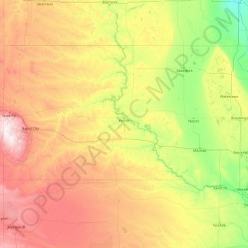
Name: Topografische Karte Süd-Dakota, Höhe, Relief.
Ort: Süd-Dakota, Vereinigte Staaten von Amerika (42.47989 -104.05776 45.94534 -96.43634)
Durchschnittliche Höhe: 717 m
Minimale Höhe: 274 m
Maximale Höhe: 2.166 m
Andere topografische Karten
Klicken Sie auf eine Karte, um ihre Topografie, ihre Höhe und ihr Relief anzuzeigen.
Black Creek Village
Vereinigte Staaten von Amerika > New York > Niagara County > City of Niagara Falls
Durchschnittliche Höhe: 176 m
Olmsted Point
Vereinigte Staaten von Amerika > Kalifornien > Mariposa County
Durchschnittliche Höhe: 2.519 m
Grand Teton
Vereinigte Staaten von Amerika > Wyoming > Teton County
Der Grand Teton ist mit einer Höhe von 4199 m der höchste Berg der Teton Range, des Grand-Teton-Nationalparks sowie des Teton County im Westen des US-Bundesstaates Wyoming. Zudem ist er nach dem Gannett Peak der zweithöchste Berg in Wyoming und der westlichste Viertausender der Rocky Mountains.
Durchschnittliche Höhe: 3.330 m
Airport Village
Vereinigte Staaten von Amerika > West Virginia > Kanawha County > Charleston
Durchschnittliche Höhe: 262 m
Meadowbrook
Vereinigte Staaten von Amerika > West Virginia > Kanawha County
Durchschnittliche Höhe: 252 m
El Capitan
Vereinigte Staaten von Amerika > Kalifornien > Mariposa County
El Capitan ist kein Berg im eigentlichen Sinn, sondern ein riesiger, durch vulkanische Schmelzprozesse entstandener Granitblock. Er fällt nach Westen, Südwesten und Südosten faktisch senkrecht und nach Osten relativ sanft zum Merced River im Yosemite-Tal bzw. in die Schluchten seiner Zuflüsse ab. Im Westen…
Durchschnittliche Höhe: 1.814 m
Bump Mountain
Vereinigte Staaten von Amerika > New York > Greene County > Town of Windham
Durchschnittliche Höhe: 635 m
Sierra Nevada
Vereinigte Staaten von Amerika > Kalifornien > Tulare County
Durchschnittliche Höhe: 3.888 m
West Toledo
Vereinigte Staaten von Amerika > Ohio > Lucas County > Toledo
Durchschnittliche Höhe: 186 m
Arbor
Vereinigte Staaten von Amerika > Kalifornien > Contra Costa County > Brentwood
Durchschnittliche Höhe: 29 m
Camp Tom Sauk
Vereinigte Staaten von Amerika > Missouri > Reynolds County
Durchschnittliche Höhe: 236 m
Triple Divide Peak
Vereinigte Staaten von Amerika > Montana > Glacier County
Durchschnittliche Höhe: 2.136 m
Denali
Vereinigte Staaten von Amerika > Alaska > Denali Borough
Der Denali oder Mount McKinley in Alaska ist mit 6190 Metern Höhe der höchste Berg Nordamerikas. Er ist damit einer der Seven Summits, der jeweils höchsten Berge der sieben Kontinente.
Durchschnittliche Höhe: 5.546 m
Yosemite Valley
Vereinigte Staaten von Amerika > Kalifornien > Mariposa County > Yosemite Village
Durchschnittliche Höhe: 2.012 m
Forest View
Vereinigte Staaten von Amerika > Tennessee > Washington County > Johnson City
Durchschnittliche Höhe: 554 m
Grant Grove Village
Vereinigte Staaten von Amerika > Kalifornien > Tulare County
Durchschnittliche Höhe: 2.015 m
Libby Dam
Vereinigte Staaten von Amerika > Montana > Lincoln County
Der 1966 bis 1972 errichtete Staudamm liegt 27 km oberhalb der Kleinstadt Libby. Der Libby Dam ist ein Mehrzweck-Projekt. Er dient dem Hochwasserschutz, der Energiegewinnung und der Erholung. Der Staudamm ist eine 916 m lange Gewichtsstaumauer aus Beton. Die Höhe über der Gründungssohle liegt bei 129 m. Der…
Durchschnittliche Höhe: 835 m
Laguna Seca
Vereinigte Staaten von Amerika > Kalifornien > Monterey County
Durchschnittliche Höhe: 206 m
Pikes Peak
Vereinigte Staaten von Amerika > Colorado > El Paso County
Pikes Peak (früher Pike’s Peak) ist ein Berg mit einer Höhe von 4301 m (14.110 Fuß) in der Front Range der Rocky Mountains, nahe Colorado Springs, Colorado. Er wurde benannt nach Zebulon Pike, einem Forschungsreisenden, der 1806 die Pike-Expedition in das südliche Colorado anführte. Es handelt sich um…
Durchschnittliche Höhe: 3.902 m
Red Rock / Tsé Łichííʼ Dah Azkání
Vereinigte Staaten von Amerika > Arizona > Apache County
Durchschnittliche Höhe: 1.780 m
Cedar Grove
Vereinigte Staaten von Amerika > Kalifornien > Fresno County
Durchschnittliche Höhe: 1.761 m
Glenwood Hills
Vereinigte Staaten von Amerika > Neumexiko > Bernalillo County > Albuquerque
Durchschnittliche Höhe: 1.937 m
Breard
Vereinigte Staaten von Amerika > Louisiana > Ouachita Parish > Monroe
Durchschnittliche Höhe: 24 m
Cinder Cone
Vereinigte Staaten von Amerika > Kalifornien > Lassen County
Durchschnittliche Höhe: 1.971 m
Orchard Garden
Vereinigte Staaten von Amerika > Minnesota > Dakota County > Burnsville
Durchschnittliche Höhe: 303 m
Wiscon
Vereinigte Staaten von Amerika > Florida > Hernando County > Brooksville
Durchschnittliche Höhe: 30 m
Monument Valley Navajo Tribal Park
Vereinigte Staaten von Amerika > Arizona > Navajo County
Das Monument Valley liegt in der Four-Corners-Region, an der Grenze zwischen Arizona und Utah, westlich der Staatsgrenzen zu Colorado und New Mexico in einer Höhe von fast 1900 m und wird bevölkerungsstatistisch in die beiden Schwestergebiete Oljato, Arizona und Oljato, Utah geteilt. Die Temperaturen im…
Durchschnittliche Höhe: 1.675 m
Omaha Beach
Vereinigte Staaten von Amerika > Iowa > Dickinson County > Okoboji
Durchschnittliche Höhe: 432 m
Sierra Nevada
Vereinigte Staaten von Amerika > Kalifornien > Tulare County
Durchschnittliche Höhe: 3.888 m
Highland Road Estates
Vereinigte Staaten von Amerika > Louisiana > East Baton Rouge Parish > Baton Rouge
Durchschnittliche Höhe: 11 m
Four Mile
Vereinigte Staaten von Amerika > Mississippi > Humphreys County
Durchschnittliche Höhe: 33 m
Newmans Pond
Vereinigte Staaten von Amerika > Georgia > Troup County > LaGrange
Durchschnittliche Höhe: 220 m
Cheops Pyramid
Vereinigte Staaten von Amerika > Arizona > Coconino County
Durchschnittliche Höhe: 1.249 m
Yellowstone Park
Vereinigte Staaten von Amerika > Texas > Harris > Houston
Durchschnittliche Höhe: 15 m
Trillium Lake
Vereinigte Staaten von Amerika > Oregon > Clackamas County
Durchschnittliche Höhe: 1.174 m
Gibson Island
Vereinigte Staaten von Amerika > Maryland > Anne Arundel County
Durchschnittliche Höhe: 23 m
Knollwood
Vereinigte Staaten von Amerika > Süd-Carolina > Greenville County > Greenville
Durchschnittliche Höhe: 283 m
Bay Port Colony
Vereinigte Staaten von Amerika > Florida > Hillsborough County
Durchschnittliche Höhe: 4 m
Dieffenbach
Vereinigte Staaten von Amerika > Pennsylvania > Montour County > Derry Township
Durchschnittliche Höhe: 172 m
Mount Rainier
Vereinigte Staaten von Amerika > Washington > Pierce County
Der Mount Rainier ist ein etwa 500.000 bis 1 Million Jahre alter Schichtvulkan. Durch sein enormes Wachstum auf eine Höhe von über 4300 Meter vergletscherte seine Spitze. Während der letzten 65.000 Jahre hat der Mount Rainier mindestens drei ausgedehnte Perioden der Vergletscherung durchgemacht. Die letzte…
Durchschnittliche Höhe: 3.912 m
Bruns
Vereinigte Staaten von Amerika > Louisiana > Iberville Parish > St. Gabriel
Durchschnittliche Höhe: 6 m
Prarie
Vereinigte Staaten von Amerika > Iowa > Linn County > Cedar Rapids
Durchschnittliche Höhe: 252 m
Talbert
Vereinigte Staaten von Amerika > Kalifornien > Orange County > Fountain Valley
Durchschnittliche Höhe: 10 m
North Fairhaven
Vereinigte Staaten von Amerika > Massachusetts > Bristol County > Fairhaven
Durchschnittliche Höhe: 11 m
Clearco
Vereinigte Staaten von Amerika > West Virginia > Greenbrier County
Durchschnittliche Höhe: 1.129 m
Mount Elbert
Vereinigte Staaten von Amerika > Colorado > Lake County
Im Vergleich zu anderen Bergen ähnlicher Höhe besitzt der Mount Elbert wenige Firnfelder, was darauf zurückzuführen ist, dass der Berg aufgrund seiner Lage und Form eine weniger effektive Wetterbarriere darstellt als umliegende Gebirgszüge und dadurch die Niederschlagsmenge geringer ist.
Durchschnittliche Höhe: 3.959 m
Cumberland Gap
Vereinigte Staaten von Amerika > Virginia > Lee County
Cumberland Gap ist der Name eines auf 488 Meter Höhe gelegenen Gebirgspasses in den Cumberland Mountains, einer Bergkette der Appalachen. Berühmt wurde er im 18. und 19. Jahrhundert als Hauptweg der weißen Siedler ins Landesinnere Nordamerikas. Der Pass war Teil der Wilderness Road, einem ehemaligen…
Durchschnittliche Höhe: 512 m
The Flatirons
Vereinigte Staaten von Amerika > Colorado > Boulder County
Durchschnittliche Höhe: 2.051 m
Mammoth
Vereinigte Staaten von Amerika > Pennsylvania > Westmoreland County > Mount Pleasant Township
Durchschnittliche Höhe: 357 m
Serrano Place
Vereinigte Staaten von Amerika > Kalifornien > Orange County > Lake Forest
Durchschnittliche Höhe: 157 m
Osprey
Vereinigte Staaten von Amerika > Florida > Sarasota County > Osprey
Durchschnittliche Höhe: 3 m
Grand Canyon
Vereinigte Staaten von Amerika > Arizona > Coconino County
Das Gebiet um das Tal wird in drei Regionen aufgeteilt: den Südrand (South Rim), der die meisten Besucher anzieht, den im Durchschnitt ca. 300 m höher gelegenen und kühleren Nordrand (North Rim) und die Innere Schlucht (Inner Canyon). Der Südrand des Grand Canyons liegt im Durchschnitt auf 2100 m ü. M.,…
Durchschnittliche Höhe: 1.023 m