Geolokalisieren

Topografische Karte Port Orchard

Interaktive Karte

Klicken Sie auf die Karte, um die Höhe anzuzeigen.

Über diese Karte

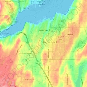
Name: Topografische Karte Port Orchard, Höhe, Relief.

Ort: Port Orchard, Kitsap County, Washington, United States (47.48174 -122.72156 47.55692 -122.60203)

Durchschnittliche Höhe: 71 m

Minimale Höhe: -3 m

Maximale Höhe: 162 m

Andere topografische Karten

Klicken Sie auf eine Karte, um ihre Topografie, ihre Höhe und ihr Relief anzuzeigen.

Seabeck

United States > Washington > Kitsap County

Durchschnittliche Höhe: 58 m

Lincoln

United States > Washington > Kitsap County > Poulsbo

Durchschnittliche Höhe: 76 m

Glenwood

United States > Washington > Kitsap County

Durchschnittliche Höhe: 105 m

Seabeck

United States > Washington > Kitsap County

Durchschnittliche Höhe: 58 m

Port Gamble

United States > Washington > Kitsap County

Durchschnittliche Höhe: 31 m

Kingston

United States > Washington > Kitsap County

Durchschnittliche Höhe: 33 m

Lofall

United States > Washington > Kitsap County

Durchschnittliche Höhe: 45 m

Wautauga Beach

United States > Washington > Kitsap County

Durchschnittliche Höhe: 21 m

Little Boston

United States > Washington > Kitsap County > Port Gamble

Durchschnittliche Höhe: 45 m

Jackson Park

United States > Washington > Kitsap County > Bremerton

Durchschnittliche Höhe: 39 m

Hansville

United States > Washington > Kitsap County

Durchschnittliche Höhe: 14 m

Blake Island

United States > Washington > Kitsap County

Durchschnittliche Höhe: 9 m

Port Orchard

United States > Washington > Kitsap County

Durchschnittliche Höhe: 61 m

Poulsbo

United States > Washington > Kitsap County > Poulsbo > Poulsbo

Durchschnittliche Höhe: 76 m

Bremerton

United States > Washington > Kitsap County > Bremerton > Bremerton

Durchschnittliche Höhe: 66 m

Lincoln

United States > Washington > Kitsap County > Poulsbo

Durchschnittliche Höhe: 76 m

Jackson Park

United States > Washington > Kitsap County > Bremerton

Durchschnittliche Höhe: 39 m