
Topografische Karte Lago Vista
Interaktive Karte
Klicken Sie auf die Karte, um die Höhe anzuzeigen.
Lago Vista
Lago Vista is situated on the northern shore of Lake Travis within the Texas Hill Country. The area's terrain is notably rugged, with steep limestone hills and canyons. Elevations range from about 774 feet near the lake to 1,220 feet near Rusty Allen Airport, making it one of the highest points in Travis County. This topography is shaped by its position within the Balcones Canyonlands, contributing to its varied landscape of sharp inclines and scenic vistas. The surrounding natural environment includes both rolling hills and steep cliffs that characterize the region.
Über diese Karte
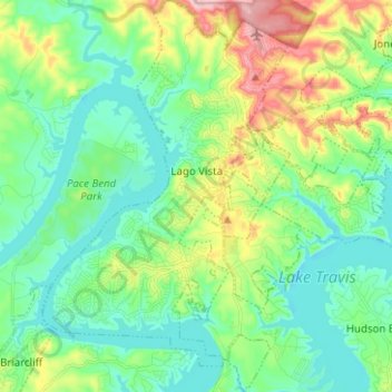
Name: Topografische Karte Lago Vista, Höhe, Relief.
Ort: Lago Vista, Travis County, Texas, United States (30.39919 -98.03744 30.50717 -97.95484)
Durchschnittliche Höhe: 251 m
Minimale Höhe: 196 m
Maximale Höhe: 388 m
Andere topografische Karten
Klicken Sie auf eine Karte, um ihre Topografie, ihre Höhe und ihr Relief anzuzeigen.
McKinney Falls State Park
United States > Texas > Travis County > Austin
Durchschnittliche Höhe: 171 m
McKinney Falls State Park
United States > Texas > Travis County > Austin
Durchschnittliche Höhe: 171 m
East Boggy Creek Greenbelt
United States > Texas > Travis County > Austin
Durchschnittliche Höhe: 144 m
Austin
United States > Texas > Travis County > Austin
The elevation of Austin varies from 425 feet (130 m) to approximately 1,000 feet (305 m) above sea level. Due to the fact it straddles the Balcones Fault, much of the eastern part of the city is flat, with heavy clay and loam soils, whereas the western part and western suburbs consist of rolling hills on the…
Durchschnittliche Höhe: 203 m
Pflugerville
United States > Texas > Travis County > Pflugerville > Pflugerville
Durchschnittliche Höhe: 219 m