
Spenden
Rüste dich für dein nächstes Abenteuer:
Als Amazon-Partner verdient diese Website an qualifizierten Käufen, ohne zusätzliche Kosten für Sie.
Topografische Karte Campbell River
Klicken Sie auf die Karte, um die Höhe anzuzeigen.
Spenden
Rüste dich für dein nächstes Abenteuer:
Als Amazon-Partner verdient diese Website an qualifizierten Käufen, ohne zusätzliche Kosten für Sie.
Über diese Karte
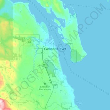
Name: Topografische Karte Campbell River, Höhe, Relief.
Durchschnittliche Höhe: 70 m
Minimale Höhe: -2 m
Maximale Höhe: 630 m
Spenden
Rüste dich für dein nächstes Abenteuer:
Als Amazon-Partner verdient diese Website an qualifizierten Käufen, ohne zusätzliche Kosten für Sie.
Andere topografische Karten
Klicken Sie auf eine Karte, um ihre Topografie, ihre Höhe und ihr Relief anzuzeigen.
Ensanada Islet
Canada > British Columbia > Strathcona Regional District > Area A (Kyuquot/Nootka/Sayward)
Durchschnittliche Höhe: 2 m
Phillips Lake
Canada > British Columbia > Strathcona Regional District > Area C (Discovery Islands/Mainland Inlets)
Durchschnittliche Höhe: 235 m
Quathiaski Cove
Canada > British Columbia > Strathcona Regional District > Area B (Discovery Islands/Mainland Inlets)
Durchschnittliche Höhe: 40 m
Heriot Bay
Canada > British Columbia > Strathcona Regional District > Area B (Discovery Islands/Mainland Inlets)
Durchschnittliche Höhe: 38 m
Spenden
Rüste dich für dein nächstes Abenteuer:
Als Amazon-Partner verdient diese Website an qualifizierten Käufen, ohne zusätzliche Kosten für Sie.
Mansons Landing
Canada > British Columbia > Strathcona Regional District > Area C (Cortes Island)
Durchschnittliche Höhe: 32 m
Discovery Mountain
Canada > British Columbia > Strathcona Regional District > Area B (Discovery Islands/Mainland Inlets)
Durchschnittliche Höhe: 361 m
Pembroke Range
Canada > British Columbia > Strathcona Regional District > Area B (Discovery Islands/Mainland Inlets)
Durchschnittliche Höhe: 633 m
Ripple Rock
Canada > British Columbia > Strathcona Regional District > Area B (Discovery Islands/Mainland Inlets)
Durchschnittliche Höhe: 40 m
Spenden
Rüste dich für dein nächstes Abenteuer:
Als Amazon-Partner verdient diese Website an qualifizierten Käufen, ohne zusätzliche Kosten für Sie.
Mount Hayes
Canada > British Columbia > Strathcona Regional District > Area B (Discovery Islands/Mainland Inlets)
Durchschnittliche Höhe: 1.101 m
Mount Raleigh
Canada > British Columbia > Strathcona Regional District > Area B (Discovery Islands/Mainland Inlets)
Mount Raleigh, elevation 3,132 m (10,276 ft), is one of the principal summits of the Pacific Ranges of the Coast Mountains of southern British Columbia in Canada. It is located just southeast of the confluence of the Southgate and Bishop Rivers, northeast of the head of Bute Inlet, and is the highest summit…
Durchschnittliche Höhe: 2.414 m
Cachalot
Canada > British Columbia > Strathcona Regional District > Area A (Kyuquot/Nootka/Sayward)
Durchschnittliche Höhe: 386 m
Whiteley Island
Canada > British Columbia > Strathcona Regional District > Area A (Kyuquot/Nootka/Sayward)
Durchschnittliche Höhe: 16 m
Spenden
Rüste dich für dein nächstes Abenteuer:
Als Amazon-Partner verdient diese Website an qualifizierten Käufen, ohne zusätzliche Kosten für Sie.
Whaletown
Canada > British Columbia > Strathcona Regional District > Area C (Cortes Island)
Durchschnittliche Höhe: 26 m
Protection Island
Canada > British Columbia > Strathcona Regional District > Area C (Cortes Island)
Durchschnittliche Höhe: 36 m
John Hart Dam
Canada > British Columbia > Strathcona Regional District > Campbell River
Durchschnittliche Höhe: 155 m
Elk Falls Viewing Platform
Canada > British Columbia > Strathcona Regional District > Campbell River
Durchschnittliche Höhe: 137 m
Spenden
Rüste dich für dein nächstes Abenteuer:
Als Amazon-Partner verdient diese Website an qualifizierten Käufen, ohne zusätzliche Kosten für Sie.
Wolf Mountain
Canada > British Columbia > Strathcona Regional District > Area D (Oyster Bay/Buttle Lake)
Durchschnittliche Höhe: 1.254 m
Oyster River
Canada > British Columbia > Strathcona Regional District > Area D (Oyster Bay/Buttle Lake) > Oyster River
Durchschnittliche Höhe: 24 m
Upana Caves
Canada > British Columbia > Strathcona Regional District > Area A (Kyuquot/Nootka/Sayward)
Durchschnittliche Höhe: 684 m
Mount Bute
Canada > British Columbia > Strathcona Regional District > Area B (Discovery Islands/Mainland Inlets)
Durchschnittliche Höhe: 1.993 m
Spenden
Rüste dich für dein nächstes Abenteuer:
Als Amazon-Partner verdient diese Website an qualifizierten Käufen, ohne zusätzliche Kosten für Sie.
Broken Islands
Canada > British Columbia > Strathcona Regional District > Area B (Discovery Islands/Mainland Inlets)
Durchschnittliche Höhe: 10 m
Victor Island
Canada > British Columbia > Strathcona Regional District > Area A (Kyuquot/Nootka/Sayward)
Durchschnittliche Höhe: 26 m
Duncan Bay
Canada > British Columbia > Strathcona Regional District > Campbell River
Durchschnittliche Höhe: 18 m
Tahsis
Canada > British Columbia > Strathcona Regional District > Tahsis > Tahsis
Durchschnittliche Höhe: 252 m
Spenden
Rüste dich für dein nächstes Abenteuer:
Als Amazon-Partner verdient diese Website an qualifizierten Käufen, ohne zusätzliche Kosten für Sie.
Flower Ridge
Canada > British Columbia > Strathcona Regional District > Area D (Oyster Bay/Buttle Lake)
Durchschnittliche Höhe: 1.095 m
Kings Peak
Canada > British Columbia > Strathcona Regional District > Area D (Oyster Bay/Buttle Lake)
Durchschnittliche Höhe: 1.435 m
Arnica Lake
Canada > British Columbia > Strathcona Regional District > Area D (Oyster Bay/Buttle Lake)
Durchschnittliche Höhe: 1.180 m