
Topografische Karte Cuernavaca
Interaktive Karte
Klicken Sie auf die Karte, um die Höhe anzuzeigen.
Über diese Karte
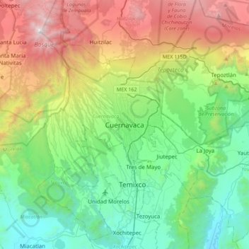
Name: Topografische Karte Cuernavaca, Höhe, Relief.
Ort: Cuernavaca, Morelos, 62000, Mexico (18.76183 -99.39423 19.08183 -99.07423)
Durchschnittliche Höhe: 1.822 m
Minimale Höhe: 965 m
Maximale Höhe: 3.679 m
The city is located in a tropical region, but its temperature is fairly constant at 21–26 °C (70–79 °F). It is located on the southern slope of the Sierra de Chichinautzin mountains. In the morning, warm air flows up the mountains from the valley below and in the late afternoon, cooler air flows down from the higher elevations. One ubiquitous flowering plant in the city is the bougainvillea.