
Topografische Karte Lillooet
Interaktive Karte
Klicken Sie auf die Karte, um die Höhe anzuzeigen.
Über diese Karte
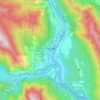
Name: Topografische Karte Lillooet, Höhe, Relief.
Durchschnittliche Höhe: 736 m
Minimale Höhe: 183 m
Maximale Höhe: 1.937 m
Andere topografische Karten
Klicken Sie auf eine Karte, um ihre Topografie, ihre Höhe und ihr Relief anzuzeigen.
Marble Canyon
Canada > British Columbia > Squamish-Lillooet Regional District > Area B (Cayoosh/Pavilion)
Durchschnittliche Höhe: 1.141 m
Whistler Mountain
Canada > British Columbia > Squamish-Lillooet Regional District > Whistler
There is a weather station near the summit of Whistler Mountain at the Roundhouse Lodge, located at an elevation of 1835 m (6020 ft). Whistler Roundhouse has a dry-summer subalpine climate (Köppen Dsc), bordering on an Alpine climate (Köppen ET).
Durchschnittliche Höhe: 1.810 m
Whistler
Canada > British Columbia > Squamish-Lillooet Regional District > Whistler Resort Municipality > Whistler
Durchschnittliche Höhe: 996 m
Mount Sloan
Canada > British Columbia > Squamish-Lillooet Regional District > Area A (Upper Bridge River Valley)
Durchschnittliche Höhe: 2.089 m
D'Arcy
Canada > British Columbia > Squamish-Lillooet Regional District > Area C (Pemberton Valley/Mount Currie/D'Arcy)
Durchschnittliche Höhe: 461 m
Mount Fergusson
Canada > British Columbia > Squamish-Lillooet Regional District > Area A (Upper Bridge River Valley)
Durchschnittliche Höhe: 2.156 m
Soprano Peak
Canada > British Columbia > Squamish-Lillooet Regional District > Area B (Cayoosh/Pavilion)
Durchschnittliche Höhe: 2.137 m
The Table
Canada > British Columbia > Squamish-Lillooet Regional District > Area D (Elaho/Garibaldi)
Durchschnittliche Höhe: 1.623 m
The Copilot
Canada > British Columbia > Squamish-Lillooet Regional District > Area D (Elaho/Garibaldi)
Durchschnittliche Höhe: 1.466 m
Mt. Mulligan
Canada > British Columbia > Squamish-Lillooet Regional District > Area D (Elaho/Garibaldi)
Durchschnittliche Höhe: 1.159 m
Ring Mountain
Canada > British Columbia > Squamish-Lillooet Regional District > Area D (Elaho/Garibaldi)
Durchschnittliche Höhe: 1.816 m
The Black Tusk (True Summit)
Canada > British Columbia > Squamish-Lillooet Regional District > Area D (Elaho/Garibaldi)
Durchschnittliche Höhe: 1.875 m
Brandywine
Canada > British Columbia > Squamish-Lillooet Regional District > Area D (Elaho/Garibaldi)
Durchschnittliche Höhe: 515 m
Spruce Lake
Canada > British Columbia > Squamish-Lillooet Regional District > Area A (Upper Bridge River Valley)
Durchschnittliche Höhe: 1.688 m
Seton Portage
Canada > British Columbia > Squamish-Lillooet Regional District > Area B (Cayoosh/Pavilion)
Durchschnittliche Höhe: 523 m
The Black Tusk
Canada > British Columbia > Squamish-Lillooet Regional District > Area D (Elaho/Garibaldi)
Durchschnittliche Höhe: 1.874 m
Metal Dome
Canada > British Columbia > Squamish-Lillooet Regional District > Area D (Elaho/Garibaldi)
Durchschnittliche Höhe: 1.678 m
Cheekye River
Canada > British Columbia > Squamish-Lillooet Regional District > Area D (Elaho/Garibaldi)
Durchschnittliche Höhe: 634 m
Bralorne
Canada > British Columbia > Squamish-Lillooet Regional District > Area A (Upper Bridge River Valley)
Durchschnittliche Höhe: 1.255 m
Furry Creek
Canada > British Columbia > Squamish-Lillooet Regional District > Area D (Elaho/Garibaldi)
Durchschnittliche Höhe: 224 m
Elfin Lakes
Canada > British Columbia > Squamish-Lillooet Regional District > Area D (Elaho/Garibaldi)
Durchschnittliche Höhe: 1.331 m
Cirque Peak
Canada > British Columbia > Squamish-Lillooet Regional District > Area C (Pemberton Valley/Mount Currie/D'Arcy)
Durchschnittliche Höhe: 1.999 m
Gun Creek
Canada > British Columbia > Squamish-Lillooet Regional District > Area A (Upper Bridge River Valley)
Durchschnittliche Höhe: 1.373 m
Onion Peak
Canada > British Columbia > Squamish-Lillooet Regional District > Area B (Cayoosh/Pavilion)
Durchschnittliche Höhe: 2.263 m
Lake La Mare Recreation Site
Canada > British Columbia > Squamish-Lillooet Regional District > Area B (Cayoosh/Pavilion)
Durchschnittliche Höhe: 1.272 m
Nairn Falls
Canada > British Columbia > Squamish-Lillooet Regional District > Area C (Pemberton Valley/Mount Currie/D'Arcy)
Durchschnittliche Höhe: 545 m
Exodus Peak
Canada > British Columbia > Squamish-Lillooet Regional District > Area C (Pemberton Valley/Mount Currie/D'Arcy)
Durchschnittliche Höhe: 2.115 m
Mount Brew
Canada > British Columbia > Squamish-Lillooet Regional District > Area D (Elaho/Garibaldi)
Durchschnittliche Höhe: 1.513 m
Minaty Bay
Canada > British Columbia > Squamish-Lillooet Regional District > Area D (Elaho/Garibaldi)
Durchschnittliche Höhe: 91 m
Mount Aragorn
Canada > British Columbia > Squamish-Lillooet Regional District > Area A (Upper Bridge River Valley)
Durchschnittliche Höhe: 2.115 m
Chipmunk Mountain West Peak
Canada > British Columbia > Squamish-Lillooet Regional District > Area A (Upper Bridge River Valley)
Durchschnittliche Höhe: 1.964 m
Brexton
Canada > British Columbia > Squamish-Lillooet Regional District > Area A (Upper Bridge River Valley)
Durchschnittliche Höhe: 975 m
Britannia Beach
Canada > British Columbia > Squamish-Lillooet Regional District > Area D (Elaho/Garibaldi)
Durchschnittliche Höhe: 208 m
Garibaldi
Canada > British Columbia > Squamish-Lillooet Regional District > Area D (Elaho/Garibaldi)
Durchschnittliche Höhe: 417 m
Panorama Ridge
Canada > British Columbia > Squamish-Lillooet Regional District > Area D (Elaho/Garibaldi)
Durchschnittliche Höhe: 1.786 m
Whistler Village
Canada > British Columbia > Squamish-Lillooet Regional District > Whistler
Durchschnittliche Höhe: 775 m
Chimney Rock
Canada > British Columbia > Squamish-Lillooet Regional District > Area B (Cayoosh/Pavilion)
Durchschnittliche Höhe: 1.506 m
Tonic Peak
Canada > British Columbia > Squamish-Lillooet Regional District > Whistler Resort Municipality
Durchschnittliche Höhe: 1.586 m
Deeks Lake
Canada > British Columbia > Squamish-Lillooet Regional District > Area D (Elaho/Garibaldi)
Durchschnittliche Höhe: 1.237 m
Aussichtspunkt auf Lilloet und Fluss
Canada > British Columbia > Squamish-Lillooet Regional District > Lillooet
Durchschnittliche Höhe: 510 m
Furry Creek
Canada > British Columbia > Squamish-Lillooet Regional District > Area D (Elaho/Garibaldi)
Durchschnittliche Höhe: 224 m
Brandywine Mountain
Canada > British Columbia > Squamish-Lillooet Regional District > Area D (Elaho/Garibaldi)
Durchschnittliche Höhe: 1.897 m
Gun Lake
Canada > British Columbia > Squamish-Lillooet Regional District > Area A (Upper Bridge River Valley)
Durchschnittliche Höhe: 1.049 m
Birken
Canada > British Columbia > Squamish-Lillooet Regional District > Area C (Pemberton Valley/Mount Currie/D'Arcy)
Durchschnittliche Höhe: 796 m
Mount Price
Canada > British Columbia > Squamish-Lillooet Regional District > Area D (Elaho/Garibaldi)
Mount Price is a small stratovolcano in the Garibaldi Ranges of the Pacific Ranges in southwestern British Columbia, Canada. It has an elevation of 2,049 metres (6,722 feet) and rises above the surrounding landscape on the western side of Garibaldi Lake in New Westminster Land District. The mountain contains a…
Durchschnittliche Höhe: 1.672 m
Whistler Village
Canada > British Columbia > Squamish-Lillooet Regional District > Whistler
Durchschnittliche Höhe: 775 m
Barrier Lake
Canada > British Columbia > Squamish-Lillooet Regional District > Area D (Elaho/Garibaldi)
Durchschnittliche Höhe: 1.405 m
Pemberton Meadows
Canada > British Columbia > Squamish-Lillooet Regional District > Area C (Pemberton Valley/Mount Currie/D'Arcy) > Pemberton Meadows
Durchschnittliche Höhe: 480 m
Cheakamus River
Canada > British Columbia > Squamish-Lillooet Regional District > Squamish
Durchschnittliche Höhe: 266 m