Topografische Karte Middleburg
Interaktive Karte
Klicken Sie auf die Karte, um die Höhe anzuzeigen.
Über diese Karte
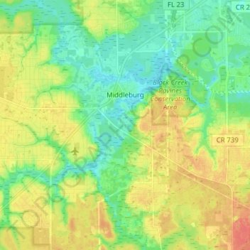
Name: Topografische Karte Middleburg, Höhe, Relief.
Ort: Middleburg, Clay County, Florida, United States (30.00158 -81.93284 30.10967 -81.84294)
Durchschnittliche Höhe: 23 m
Minimale Höhe: 0 m
Maximale Höhe: 50 m
Andere topografische Karten
Klicken Sie auf eine Karte, um ihre Topografie, ihre Höhe und ihr Relief anzuzeigen.
Keystone Heights
United States > Florida > Clay County
Keystone Heights, Clay County, Florida, United States
Durchschnittliche Höhe: 41 m
Green Cove Springs
United States > Florida > Clay County
Green Cove Springs, Clay County, Florida, United States
Durchschnittliche Höhe: 8 m
Orange Park
United States > Florida > Clay County
Orange Park, Clay County, Florida, United States
Durchschnittliche Höhe: 5 m
Fleming Island
United States > Florida > Clay County
Fleming Island, Clay County, Florida, 32003, United States
Durchschnittliche Höhe: 19 m
Bellair
United States > Florida > Clay County
Bellair, Clay County, Florida, 32073, United States
Durchschnittliche Höhe: 12 m
Highland
United States > Florida > Clay County
Highland, Clay County, Florida, United States
Durchschnittliche Höhe: 55 m
Oakleaf
United States > Florida > Clay County > Oakleaf
Oakleaf, Clay County, Florida, 32222, United States
Durchschnittliche Höhe: 18 m
Middleburg
United States > Florida > Clay County > Middleburg
Middleburg, Clay County, Florida, 32068, United States
Durchschnittliche Höhe: 10 m
Asbury Lake
United States > Florida > Clay County
Asbury Lake, Clay County, Florida, United States
Durchschnittliche Höhe: 22 m
Bellair-Meadowbrook Terrace
United States > Florida > Clay County > Bellair
Bellair-Meadowbrook Terrace, Bellair, Clay County, Florida, 32073, United States
Durchschnittliche Höhe: 10 m