
Topografische Karte Tagum
Interaktive Karte
Klicken Sie auf die Karte, um die Höhe anzuzeigen.
Tagum
One of the significant accomplishments of the officialdom of Tagum during the 1990s was its elevation from a second to the first-class municipality. This opened a gateway to increase its financial resources through the Internal Revenue Allocation (IRA) from the national government and local revenues.
Über diese Karte
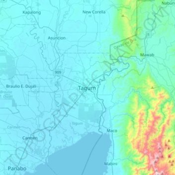
Name: Topografische Karte Tagum, Höhe, Relief.
Ort: Tagum, Davao del Norte, Davao Region, 8100, Philippines (7.28702 125.65118 7.60702 125.97118)
Durchschnittliche Höhe: 103 m
Minimale Höhe: 0 m
Maximale Höhe: 1.143 m