
Topografische Karte Lava Hot Springs
Interaktive Karte
Klicken Sie auf die Karte, um die Höhe anzuzeigen.
Über diese Karte
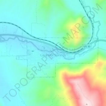
Name: Topografische Karte Lava Hot Springs, Höhe, Relief.
Durchschnittliche Höhe: 1.611 m
Minimale Höhe: 1.516 m
Maximale Höhe: 1.896 m
Lava Hot Springs is located at 42°37′10″N 112°0′51″W / 42.61944°N 112.01417°W / 42.61944; -112.01417 (42.619482, -112.014283), at an elevation of 5,020 feet (1,530 m) above sea level.
Andere topografische Karten
Klicken Sie auf eine Karte, um ihre Topografie, ihre Höhe und ihr Relief anzuzeigen.
Pocatello
United States > Idaho > Bannock County
Pocatello, Bannock County, Idaho, United States
Durchschnittliche Höhe: 1.580 m
Downey
United States > Idaho > Bannock County
Downey, Bannock County, Idaho, United States
Durchschnittliche Höhe: 1.482 m
Fort Hall
United States > Idaho > Bannock County
Fort Hall, Bannock County, Idaho, United States
Durchschnittliche Höhe: 1.377 m
Chubbuck
United States > Idaho > Bannock County
Chubbuck, Bannock County, Idaho, 83202, United States
Durchschnittliche Höhe: 1.377 m
McCammon
United States > Idaho > Bannock County
McCammon, Bannock County, Idaho, United States
Durchschnittliche Höhe: 1.465 m
Inkom
United States > Idaho > Bannock County
Inkom, Bannock County, Idaho, United States
Durchschnittliche Höhe: 1.447 m