Geolokalisieren

Topografische Karte Casula

Interaktive Karte

Klicken Sie auf die Karte, um die Höhe anzuzeigen.

Casula

Casula is the first suburb immediately south of Liverpool on the Hume Highway and the Main Southern railway line between Sydney and Melbourne. Casula consists of undulating, gently rolling land, with elevations across the suburb being mostly between 30 and 70 metres above sea level. The Georges River forms the eastern boundary of the suburb, and its western bank is paralleled by a relatively steep escarpment.

Wikipedia (CC-BY-SA 3.0)

Über diese Karte

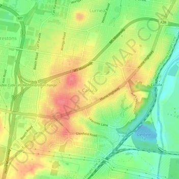
Name: Topografische Karte Casula, Höhe, Relief.

Ort: Casula, Sydney, Liverpool City Council, New South Wales, 2170, Australia (-33.96678 150.87469 -33.93749 150.91905)

Durchschnittliche Höhe: 34 m

Minimale Höhe: -9 m

Maximale Höhe: 68 m

Andere topografische Karten

Klicken Sie auf eine Karte, um ihre Topografie, ihre Höhe und ihr Relief anzuzeigen.

Springwood Park

Australia > New South Wales > Sydney > Springwood

Durchschnittliche Höhe: 341 m

Barnett Park

Australia > New South Wales > Sydney

Durchschnittliche Höhe: 51 m

Warren Reserve

Australia > New South Wales > Sydney

Durchschnittliche Höhe: 47 m

Primrose Park

Australia > New South Wales > Sydney

Durchschnittliche Höhe: 57 m

Pulpit Hill

Australia > New South Wales > Sydney

Durchschnittliche Höhe: 954 m

Merric Circle

Australia > New South Wales > Sydney

Durchschnittliche Höhe: 49 m

Dights Hill

Australia > New South Wales > Sydney > Richmond

Durchschnittliche Höhe: 18 m

North Cronulla Beach

Australia > New South Wales > Sydney

Durchschnittliche Höhe: 8 m

Cronulla Beach

Australia > New South Wales > Sydney

Durchschnittliche Höhe: 9 m

Deep Creek Reserve

Australia > New South Wales > Sydney

Durchschnittliche Höhe: 50 m

Wynyard Park

Australia > New South Wales > Sydney

Durchschnittliche Höhe: 20 m

Snapper Island

Australia > New South Wales > Sydney

Durchschnittliche Höhe: 13 m

Prospect Hill

Australia > New South Wales > Sydney

As at 19 February 2001, the Prospect Hill area had state significance due to its unique combination of significant landscape feature, potential archaeological site, and association with important historical phases. As a dolerite outcrop rising to a height of 117 metres (384 ft) AHD , Prospect Hill is a rare…

Durchschnittliche Höhe: 65 m

Prospect Reservoir

Australia > New South Wales > Sydney

Durchschnittliche Höhe: 62 m

Orion Place Reserve

Australia > New South Wales > Sydney

Durchschnittliche Höhe: 108 m

Sydney Observatory

Australia > New South Wales > Sydney

The place has an association with an extensive array of historical figures most of whom have helped shape its fabric. These include: colonial Governors Hunter, Bligh, Macquarie & Denison; military officers and engineers Macarthur; Barrallier; Bellasis and Minchin; convicts: the as yet unnamed constructors of…

Durchschnittliche Höhe: 14 m

Anzac Park

Australia > New South Wales > Sydney

Durchschnittliche Höhe: 45 m

Pembroke Park

Australia > New South Wales > Sydney

Durchschnittliche Höhe: 70 m

Locke Park

Australia > New South Wales > Sydney

Durchschnittliche Höhe: 46 m

Berry Island Reserve

Australia > New South Wales > Sydney

Durchschnittliche Höhe: 24 m

Rose Seidler House

Australia > New South Wales > Sydney

Durchschnittliche Höhe: 153 m

Woronora

Australia > New South Wales > Sydney

Durchschnittliche Höhe: 195 m

Warragamba Dam

Australia > New South Wales > Sydney > Warragamba

Durchschnittliche Höhe: 156 m

Shark Island

Australia > New South Wales > Sydney

Durchschnittliche Höhe: 7 m

Eric Primrose Reserve

Australia > New South Wales > Sydney

Durchschnittliche Höhe: 15 m

Mount Annan

Australia > New South Wales > Sydney

Durchschnittliche Höhe: 115 m

Sydney Water Supply Canal

Australia > New South Wales > Sydney

Durchschnittliche Höhe: 99 m

Eastern Channel Pile Light

Australia > New South Wales > Sydney

Durchschnittliche Höhe: 10 m

Goroka Park

Australia > New South Wales > Sydney

Durchschnittliche Höhe: 103 m

Chowder Bay

Australia > New South Wales > Sydney

Durchschnittliche Höhe: 24 m

Dantes Glen

Australia > New South Wales > Sydney > Lawson

Durchschnittliche Höhe: 689 m

Manly Cove

Australia > New South Wales > Sydney

Durchschnittliche Höhe: 20 m

Coogee Beach

Australia > New South Wales > Sydney

Durchschnittliche Höhe: 31 m

Pirrama Park

Australia > New South Wales > Sydney

Durchschnittliche Höhe: 15 m

Attunga Reserve

Australia > New South Wales > Sydney

Durchschnittliche Höhe: 35 m

Dalmeny Reserve

Australia > New South Wales > Sydney

Durchschnittliche Höhe: 42 m

Sydney Water Supply Canal

Australia > New South Wales > Sydney

Durchschnittliche Höhe: 115 m

Sydney City Marine

Australia > New South Wales > Sydney

Durchschnittliche Höhe: 16 m

Sydney Rock

Australia > New South Wales > Sydney > Lawson

Durchschnittliche Höhe: 671 m

Sydney Water Supply Canal

Australia > New South Wales > Sydney

Durchschnittliche Höhe: 65 m

Gymea Bay

Australia > New South Wales > Sydney

Durchschnittliche Höhe: 29 m

Green Point Reserve

Australia > New South Wales > Sydney

Durchschnittliche Höhe: 22 m

The Peninsular

Australia > New South Wales > Sydney

Durchschnittliche Höhe: 9 m

Sydney Smith Park

Australia > New South Wales > Sydney

Durchschnittliche Höhe: 29 m

Upper Leura Cascades

Australia > New South Wales > Sydney

Durchschnittliche Höhe: 909 m

Sydney Water Supply Canal

Australia > New South Wales > Sydney

Durchschnittliche Höhe: 111 m

The Basin

Australia > New South Wales > Sydney

Durchschnittliche Höhe: 91 m

Harold Park

Australia > New South Wales > Sydney

Durchschnittliche Höhe: 20 m

Sydney Water Supply Canal

Australia > New South Wales > Sydney

Durchschnittliche Höhe: 114 m

Sydney Water Supply Canal

Australia > New South Wales > Sydney

Durchschnittliche Höhe: 74 m

Scarbourgh Park East

Australia > New South Wales > Sydney

Durchschnittliche Höhe: 7 m